

Malaysia Airlines Missing Plane Not On Google Maps: Google Reminds Concerned Users That Satellite Images Are Not Live

As the search continues for Malaysia Airlines Flight MH370, the Boeing 777 that disappeared about one hour into its flight from Kuala Lumpur to Beijing, many concerned people have turned to Google Maps in an attempt to locate the missing airplane.
Several users claim that they actually found it.
Several satellite images on Google Maps near the Vietnamese island of Cầu Ma Thiên Lãnh clearly show an airplane. Other users claim they spotted Flight MH370 near Kenyir Dam in Terengganu.
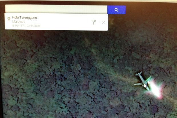
Unfortunately, it isn’t possible for these images to actually be Flight MH370, as satellite images on Google Maps are taken several weeks or months before they appear on Google Maps.
This fact hasn’t stopped hopeful seekers, and the rumors gained enough momentum that Google Inc. (NASDAQ:GOOG) Malaysia issued a statement to remind users that the images on Google Maps are old.
“Yes, the images may be there, but it is not real time satellite images as the images may have provided to us several weeks or months ago [sic],” a Google Malaysia spokesperson told Malaysian newspaper The Star. “These images which are captured would sometimes contain images of airplanes usually on its flight path and cannot be presumed as a possible crash site.”
This isn’t the first time images captured for Google Maps have been used to draw spurious conclusions. Users have on at least two occasions claimed to have found evidence of a murder on Google Maps.
That’s not to say that it isn’t possible. Google has actually captured a murder scene before, and Google Maps has played a role in solving a crime on several occasions. Google Maps also captured the last living photograph of a man’s deceased grandmother.
As for Malaysia Airlines Flight MH370, officials said on Wednesday that the search area has been expanded to 100 nautical miles (115 miles) to include the Andaman Sea.
© Copyright IBTimes 2025. All rights reserved.
- MOST POPULAR IN Internet


