

Mars Express' Photo Captures Landscape Carved By Red Planet’s Volcanic Activity
KEY POINTS
- ESA shared a photo of Mars taken by the Mars Express
- The photo shows signs of Mars volcanic activity
- The image shows the effect if lava flows and faults
The European Space Agency (ESA) has shared a new image of Mars taken by its Mars Express orbiter. It shows a region of the Red Planet that was severely affected by its volcanic activity.
Mars Express is a mission launched by the ESA to the Red Planet in June 2003. It features an orbiter that was designed to study Mars and its surface from high altitudes.
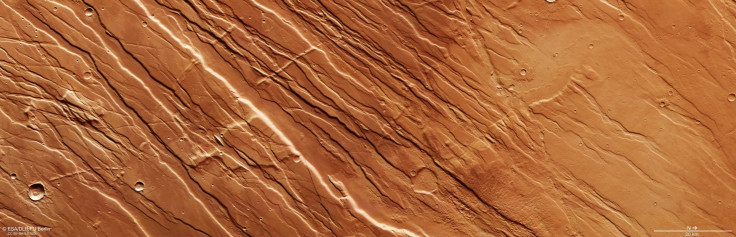
ESA’s image features a province on Mars known as Tharsis. It comprises of data collected by the Mars Express in September last year. As explained by the agency, Tharsis is characterized by signs of volcanic and tectonic activities on Mars.
It features a landscape that was ravaged by the planet’s geological activities. According to the ESA, the photo showcases two distinct Martian terrain features know as grabens and horsts. Grabens are portions of the ground that have fallen between two parallel faults. Horsts, on the other hand, moved upwards due to the movements of the faults.
“Both were created by tremendous volcanic and tectonic forces acting across the surface of Mars, which fractured the ground and manipulated it into new configurations,” the ESA explained in a statement.
Aside from these, the ESA also noted that although the photo only shows one region, the terrain shows varying features. While the right half of the photo shows a smoother landscape, the other half features streaks on the ground.
According to the ESA, the smooth surfaces on Tharsis were created by lava flows that flooded the region. Eventually, the lava cooled and solidified.
As for the streaks on the ground, the ESA noted that these were caused by the effect expansion of the region on the ground.
“The surface to the right of the frame is smoother, created as lava flooded the region before cooling and solidifying, and some perpendicular slices across the predominantly parallel ridges can be seen to the left of the frame,” the ESA explained. “As the nearby Tharsis province grew larger, it stretched and stressed the surrounding crust – and these features are evidence of a change in the direction of stress.”
© Copyright IBTimes 2025. All rights reserved.
- MOST POPULAR IN Science


