

Satellite Image Shows Fire Activity Along Drought-Parched River

KEY POINTS
- Drought has caused the water levels in Argentina's Paraná river to drop significantly
- Its water levels are at its lowest in over 40 years
- The dry conditions have aided the increase in fire activity in the area
A drought in Argentina, Brazil and Paraguay has pushed the Paraná River to its lowest water level in over 40 years. Satellite images show the startling change and also the fire activity in the area due to the dry conditions.
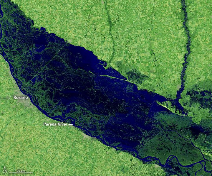
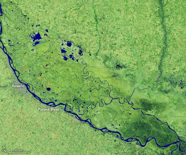
A persistent drought since early 2020 has caused the water levels in Argentina's Paraná River to drop significantly. In the images captured by Landsat 8 satellite and shared by NASA Earth Observatory, one can see the startling difference in the water levels from July last year and this year.
In the false-color image captured by the Landsat 8 satellite's Operational Land Imager (OLI) on July 1, 2019, the water levels were still high across the various parts of the delta, with the parts in dark blue or black representing water.
An image of the same region a year later on July 3, 2020, shows a complete change in the area.
Even if the current water level in Paraná River is at its lowest in decades, the situation was worse and more frequent before the 1970s, said Andrés Antico, a climatologist with Argentina’s National Scientific and Technical Research Council. This was prior to the construction of the dams that now allow for the release of reservoir water when it gets too dry.
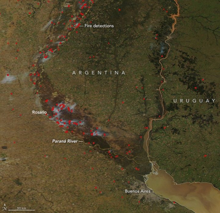
The current water level problem is also contributing to another problem in the area: an increase in fire activity.
In a natural-color satellite image of the area captured by the Aqua satellite's Moderate Resolution Imaging Spectroradiometer (MODIS) instrument on July 14, 2020, the red dots mark the temperatures associated with fire detections in the area on that day, many of which were quite close to the river.
In some parts, the warm temperature detections were clustered close to each other, while the others are farther away.
MODIS detected over 1,450 hotspots in the area in 2020 through to July 22, which is more than any other year since 2008.
The lower water levels in the area appear to have aided the spread of the fires by exposing more shrubs and grassland. And with some of the fires being intentionally set, for instance, to clear out vegetation, the dry conditions made it easier for the fires to go out of control.
The smoke from the fires has been affecting nearby cities such as Rosario, San Lorenzo and Empalme. This is also problematic for the biodiversity in the area, as the land around the river is also home to a variety of flora and fauna, including 700 species of vascular plants, 27 amphibians, 300 fish and 260 birds.
As a result, authorities have declared an environmental emergency and prohibited all burnings in the area for 180 days.
Although the area did receive rain in recent months, in May, Argentina's National Water Institute noted that the low water levels will likely remain for the rest of the year. This is problematic for the industries that rely on the river for movement and also for the people, animals and vegetation that rely on the region.
© Copyright IBTimes 2025. All rights reserved.
- MOST POPULAR IN Science


