

Spratly Islands: The Contested Archipelago Threatening To Blow Up The Fraught Philippines-China Relationship

KEY POINTS
- China and the Philippines have asserted territorial claims over the Second Thomas Shoal for years
- Incidents of Chinese Coast Guard ships blocking Philippine vessels near the area have been reported over the years
- Both countries have built up infrastructure in parts of the Spratlys, but China has carried out much more reclamation activities
- Taiwan, Vietnam, Malaysia and Brunei also have overlapping claims in parts of the Spratlys
China and the Philippines are once again engaged in a war of words over a section of the Spratly Islands that both countries claim as part of their territory. But what does international law say about the contested archipelago and who is winning the race toward developing the resource-rich islands?
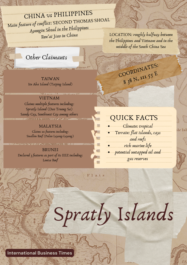
Where are the Spratly Islands?
With more than 100 small islands, reefs and cays skirting fishing grounds rich with marine life, the Spratly Islands are located roughly halfway between the Philippines and Vietnam, in the middle of the South China Sea.
Only around 45 islands across the vast 158,000-square mile (around 410,000 square kms) group of islands and reefs are occupied by military forces from China, the Philippines, Malaysia, Vietnam and Taiwan. The island group's coastline spans around 575 miles (926 kms).
New wounds
Tensions between China and the Philippines have escalated in recent weeks over an atoll in the Spratlys: the Second Thomas Shoal, which is located roughly 105 nautical miles (194 kms or 121 miles) west of Palawan, Philippines.
Known as Ayungin Shoal in the Philippines and Ren'ai Jiao in China, Second Thomas Shoal is the atoll where the Philippines deliberately grounded a warship, the BRP Sierra Madre, in the 1990s to assert Manila's sovereignty over the area.
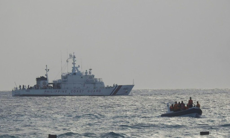
The Philippines has accused China of "interfering" in efforts to carry out resupply missions to the Filipino marines stationed on the grounded ship.
Last week, Beijing said it had "indisputable sovereignty" over the Spratly Islands, which it calls Nansha Qundao, "including Ren'ai Jiao." Armed Forces of the Philippines (AFP) spokesperson Col. Medel Aguilar rejected China's claims, citing the United Nations Convention on the Law of the Sea (UNCLOS) and Manila's 2016 international arbitral victory in its case against China's territorial claims.
Old scars
In August, the countries had another tense exchange of words after the Chinese Coast Guard (CCG) fired a water cannon on Philippine vessels, which were escorted by the Philippine Coast Guard (PCG), on a resupply mission to the Second Thomas Shoal. Manila called the move "illegal" and "dangerous," and Beijing said it took the necessary measures because the Philippines allegedly reneged on an agreement to remove the BRP Sierra Madre from Ayungin Shoal. China also said Manila was trying to refurbish the derelict ship.
Philippine President Ferdinand "Bongbong" Marcos Jr. said he was unaware of a deal to tow away the grounded ship. "If there does exist such an agreement, I rescind that agreement as of now," he said.
I'm not aware of any agreement that the Philippines should remove from its own territory its own ship, the BRP Sierra Madre, from the Ayungin Shoal.
— Bongbong Marcos (@bongbongmarcos) August 9, 2023
And let me go further, if there does exist such an agreement, I rescind that agreement as of now. pic.twitter.com/PrOXMg1bRT
The encounters have a long history. In March 2014, journalists witnessed how a CCG ship attempted to block the path of a PCG vessel on a resupply mission to the disputed shoal. The Philippine ship evaded the blockade, but there was growing concern over Beijing's increasing "assertiveness" in the area.
In November 2021, a similar incident took place, with Manila condemning "in the strongest terms" the actions of three CCG vessels that blocked Philippine ships bringing supplies to Filipino personnel at the BRP Sierra Madre. At the time, the Philippine resupply mission had to be aborted because of the escalating tensions.
10-dash line vs. 2016 arbitral award
China has claimed sovereignty over virtually the entire South China Sea, citing its supposedly historically-based records and backed by its now-upgraded 10-dash line. The line is a series of 10 dashes on a map of the South China Sea, used by Beijing to demarcate its expansive claims in the territorial waters.
Interestingly, it used to be a line of nine dashes and was called the nine-dash line. China added one more dash recently to bring the island state of Taiwan within its claims.
Since winning in an international arbitral court in 2016 against China, the Philippines has been using its arbitral award to assert its claims over parts of the Spratly Islands as well as another highly disputed feature, the Scarborough Shoal.
In a press release from The Hague, Arbitral Tribunal gives the Philippines a unanimous award in its case vs China. pic.twitter.com/QKod2bXu80
— Raffy Tima (@raffytima) July 12, 2016
"With respect to the Philippines' Submission No. 5, the Tribunal concludes that both Mischief Reef (Panganiban Reef in the Philippines) and Second Thomas Shoal are located within the 200 nautical miles of the Philippines' coast on the island of Palawan and are located in an area that is not overlapped by the entitlements generated by any maritime feature claimed by China. It follows, therefore, that, as between the Philippines and China, Mischief Reef and Second Thomas Shoal form part of the exclusive economic zone and continental shelf of the Philippines," the award stated.
The award further noted that "there is no legal basis for any Chinese historic rights, or other sovereign rights and jurisdiction beyond those provided in the Convention (UNCLOS), in the waters of the South China Sea encompassed by the 'nine-dash line'."
A race to reclamation?
Even though the Second Thomas Shoal is at the center of recent tensions between the two Asian countries, there has not been much reclamation activities in the area so far.
Instead, both China and the Philippines have worked on developing other features across the archipelago, as have some of the other claimants.
China, in particular, has seven military outposts in the Spratly Islands and 20 outposts in the Paracel Islands, which Vietnam has overlapping claims over.
Beijing has been building infrastructure in the Spratlys' Cuarteron Reef (Huayang Jiao), Fiery Cross Reef (Yongshu Jiao), Gaven Reefs (Nanxun Jiao), Hughes Reefs (Dongmen Jiao), Johnson Reef (Chiguo Jiao), Mischief Reef (Meiji Jiao), Subi Reef (Zhubi Jiao), and Antelope Reef (Lingyang Jiao), among around a dozen others.
Massive China reclamation in West PHL Sea,Calderon (Cuarteron) Reef. Courtesy:@ace_magdalo | via @wengsalvacion @dzbb pic.twitter.com/JNCFhWL9kC
— GMA Integrated News (@gmanews) March 16, 2015
The Philippines, on the other hand, occupies nine features in the Spratlys, including Commodore Reef (Rizal Reef), Flat Island (Patag Island), Loaita Cay (Melchora Aquino Cay or Panata Island), and Thitu Island (Pag-asa Island), which has an airstrip and a civilian population.
Late last week, the Philippine Navy warned off a Chinese naval warship after it "shadowed the former at an 80-yard (73 meters) distance and attempted to cross" the bow of the Philippine Navy's BRP Benguet near Thitu Island.
What makes the Spratlys special?
The disputed archipelago is believed to be rich in natural resources, such as untapped oil and natural gas reserves. It is also strategically located near some of the region's primary shipping lanes, specifically across central South China Sea.
Named after British whaling captain Richard Spratly, who first discovered Spratly Island in 1834, the archipelago is the subject of a 2005 joint agreement between national oil companies from China, the Philippines and Vietnam to conduct marine seismic activities. The Philippine Supreme Court has since ruled the joint exploration deal void, saying the agreement was "unconstitutional."
Who are the other claimants?
Besides China and the Philippines, Taiwan, Vietnam, Malaysia and Brunei have also asserted their claims over parts of the Spratly Islands.
Taiwan claims Itu Aba Island, which it calls Taiping Island and started regularly occupying the area in 1956. It has developed the island since then and as of 2018 had between 150 and 200 people living in the island as per The New York Times.
Vietnam has many claims over the Spratlys, including Sandy Cay, Southwest Cay and Amboyna Cay among others. For one, it claims Spratly Island, which it calls Dao Truong Sa. It seized the feature in 1974 and has built up major infrastructure on the island as seen in aerial photos.
Vietnam's Spratly Island in the South China Sea pic.twitter.com/CRdQoYGRDC
— Duan Dang (@duandang) May 1, 2018
Malaysia is claiming 10 maritime features in the southern section of the Spratlys, according to the National Bureau of Asian Research (NBR), and it has control over seven of the said features, including Swallow Reef, which it has occupied since 1983.
Finally, Brunei, which has limited claims in the area, declared Louisa Reef, Rifleman Bank and Owen Shoal as part of its EEZ in 1984. However, unlike other claimants, observers noted that Brunei has been "cautious" in asserting its territorial claims.
What happens now?
The fate of the hotly contested Spratly Islands is yet to be decided. Observers have said there is the possibility of an armed conflict, especially with escalating tensions between China and the Philippines.
A Philippine maritime expert said last week that China's latest actions – a CCG vessel allegedly coming within a meter (3 feet) of colliding with a PCG patrol ship – suggest that Beijing was pushing Manila to make the first move so it can use it as an excuse to make a "disproportionate" response.
Manila has vowed to stand its ground, even launching a dedicated website titled "Not One Inch" to spread awareness about its 2016 arbitral victory, but experts have warned its military arsenal cannot compare to Beijing's in the event of an armed attack.
The Philippines' DFA launches a microsite to commemorate the 7th anniversary of the South China Sea arbitration award. "Not one inch" is a reference to a line from President Ferdinand Marcos Jr.'s 2022 SONA. | via @beacupin
— Rappler (@rapplerdotcom) July 12, 2023
Check it out here: https://t.co/oz3rNGEKZo pic.twitter.com/HRuePZsqRX
Observers have pointed out that Marcos' responses to Chinese "bullying" in the contested waters was different than that of his predecessor, Rodrigo Duterte, handled China's aggression as the former has been hardening its stance over the West Philippine Sea.
It remains to be seen how the Marcos administration's alliances with the U.S. and other nations could help bolster a smaller country's resolve in pushing back against Beijing's iron hand.
© Copyright IBTimes 2024. All rights reserved.
- MOST POPULAR IN World


