

‘Desert Breath’ Seen From Google Earth, Mysterious Spiral In Egypt Symbolizes The ‘Passage Of Time’ [PHOTO]

A mysterious spiral seen from space had some Google Earth users wondering where it came from.
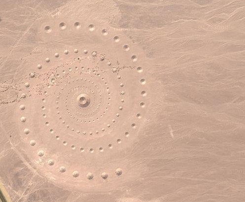
The set of dots that form the spiral in the Egyptian desert belong to an environmental art installation built in March 1997, LiveScience reports. Known as “Desert Breath,” the artwork takes up 100,000 square meters in the eastern Sahara bordering the Red Sea in El Gouna.
“Located between the sea and a body of mountains at the point where the immensity of the sea meets the immensity of the desert, the work functions on two different levels in terms of viewpoint: from above as a visual image, and from the ground, walking the spiral pathway, a physical experience,” D.A.S.T. Artstream writes in its description of the work.
The work uses precise positive and negative conical volumes of sand (i.e. mounds and holes) to create two interlocking spirals that emanate from a common center. Desert Breath is slowly disintegrating since the sand is blowing off the cone-shaped hills – a element noted by the creators to symbolize the “passage of time.”
The spiral’s center, which was once a bright blue lake, has dried up along with other features that have been swept away by the winds.
On Google Earth, the image is visible at the coordinates 27°22'54.59"N, 33°37'48.46"E or here.
This isn’t the first image that has puzzled Google Earth viewers. A memorial dedicated to UTA Flight 772 in the Tenere region of the Sahara Desert caught users by surprise. It was made from dark stones that created a 260-foot emblem -- the actual size of the DC-10 aircraft – and pointed in the direction of its intended flight path.
The flight, which was en route from Brazzaville in the Republic of Congo to Paris in 1989, crashed over a remote part of Niger from a bomb that was planted in the plane’s luggage. The crash site was 400 miles from any nearby town and its debris remains among the sand dunes to this day.
© Copyright IBTimes 2024. All rights reserved.
- MOST POPULAR IN Technology


