

NASA Mission Captures Stunning Image Of Sandstone Layers On Mars
KEY POINTS
- NASA shared a new photo taken by the MRO spacecraft
- The photo features layered sandstone deposits on Mars
- Scientists plan to interpret Mars' geological features
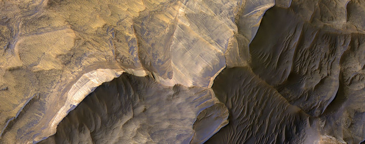
NASA’s ongoing mission on Mars recently captured a stunning photo of the Red Planet’s landscape. The image featured layered natural deposits that are believed to be sandstones.
The latest photo shared by NASA was taken by its Mars Reconnaissance Orbiter (MRO). The image was taken using its Compact Reconnaissance Imaging Spectrometer for Mars (CRISM) instrument and the High Resolution Imaging Science Experiment (HiRISE).
The MRO was officially launched by NASA on Aug. 12, 2005. After traveling for almost a year in space, the unmanned spacecraft finally reached the orbit of Mars on March 10, 2006. For almost 14 years, the MRO has been orbiting the Red Planet. Using the CRISM and HiRISE, the MRO has been taking highly-detailed photos of Mars from space.
Recently the spacecraft took a photo of Mars’ Candor Chasma region located in the central Valles Marineris. From above, the image looks like a wave moving across the surface.
According to the HiRISE team at the University of Arizona’s Lunar and Planetary Laboratory, MRO’s latest photo features layered deposits that are believed to be composed of sandstones. The scientists believe that these may have formed long ago when the region was still wet and possibly habitable.
“Candor Chasma in central Valles Marineris is filled with light-toned layered deposits thought to be sandstones, perhaps formed in an ancient wet and potentially habitable environment,” the team explained in a statement.
According to members of the team, they plan to carry out further studies on the region by simultaneously using the MRO’s CRISM and HiRISE. Through the images that will be captured by these instruments, the scientists are hoping to come up with clear interpretations of the region’s distinct geological features.
“We are now trying to complete coordinated coverage over such locations, to enable geologic interpretations based on both the compositional information of CRISM and the high-resolution imaging of HiRISE,” the team stated.
The information that will be collected through these follow-up studies could be used to guide NASA’s future human mission to Mars, which the agency intends to launch as part of its Artemis spaceflight program.
© Copyright IBTimes 2025. All rights reserved.
- MOST POPULAR IN Science


