

Caldor Fire Is Top Threat Among 9 Major Fires In California: Latest News, Evacuation Orders, Air Quality Warning

KEY POINTS
- Caldor Fire has burned more than 122,980 acres
- Air quality in a “hazardous” state around South Lake Tahoe
- Highway 50 remains closed
- El Dorado National Forest will be closed until Sept. 30
The Caldor Fire that broke out 10 days ago in El Dorado County has become the top threat among the nine major fires burning across Northern California as it has only been 11 percent contained.
The latest report from CAL Fire timed 7 p.m. Tuesday said the fire has grown to 122,980 acres and has destroyed 637 structures so far, including 11 commercial properties, 165 minor structures and 461 single residences.
The nine active fires have together burned nearly 1.3 million acres. The Dixie fire, the largrst one active now and the second-largest ever in California history, has burned 140 square miles in five counties. It has been burning for more than six weeks now. It is about 40% contained.
The Antelope Fire, which is about a third contained, has burned 69,700 acres.
California Gov. Gavin Newsom has since requested a major disaster declaration from U.S. President Joe Biden, CNN reported. If granted, the state will receive assistance as it battles with the blazes.
The #CaldorFire Incident Update: 8/24/21 PM
— CAL FIRE AEU (@CALFIREAEU) August 25, 2021
(5/5 is in the next tweet in this thread) @EldoradoNF @ElDoradoSheriff pic.twitter.com/JJqVbXw1AD
Multiple areas across El Dorado County have been issued with evacuation orders, while some areas in Amador County, including the Eastern border of the Alpine County line, are under evacuation warnings.
The following areas have been issued local evacuation orders:
- Grizzly Flats: Areas on Grizzly Flats Road east of Kendra Way into Grizzly Flats Proper
- Areas around Diamond Railroad Grade, Old School House, Sweeney Road, Caldor Road, and Steely Ridge
- All roads off of Omo Ranch from Cedarville Road to Highway 88
- South of Highway 50 from Snows Road to Ice House Road
- Area between Highway 88 and Mormon Emigrant Trail
- Silver Fork Road in Kyburz to Twin Bridges
- Areas south of Farnham Ridge Road
- East of Bridgeport School Road to the Amador County Line
- Slug Gulch, Omo Ranch, and all roads off of Slug Gulch and Omo Ranch
- East side of Fairplay Road from Perry Creek South to Cedarville Road
In regards to Lake Tahoe and the #CaldorFire, fire officials during their 6pm meeting said IF the area between Twin Bridges/Echo Summit goes under evacuation orders, that would also trigger some evacuation warnings into the Tahoe Basin. Wouldn't say where exactly. pic.twitter.com/GTZXzZCU4m
— Drew Tuma (@DrewTumaABC7) August 25, 2021
Click here for an in-depth list of evacuation orders, including warnings across El Dorado County and Amador County.
Road Closures
- Highway 50, no estimated time of reopening as of Tuesday
- The section of Highway 50 between Twin Bridges and Meyers will be open for local residents residing in the said area (proof of residency and identification are required)
- Traffic not permitted west past Twin Bridges
National Forest Closures Through Sept. 6
- El Dorado National Forest will be closed until at least Sept. 30
- Shasta-Trinity National Forest
- Modoc National Forest
- Tahoe National Forest
- Six Rivers National Forest
- Plumas National Forest
- Lassen National Forest
- Klamath National Forest
- Mendocino National Forest
- Lake Tahoe Basin Management Unit
In its latest update on air quality in the United States, airborne pollutant monitoring company IQ Air said Minden in Nevada is currently the most polluted city in the country, followed by South Lake Tahoe in California. Anything beyond 200 in the air quality index is unhealthy for residents. Minden and South Lake Tahoe posted a score of 451 and 429 Tuesday, respectively. Business owners have said the smoke is affecting businesses in the area.
Air Quality Updates
- Washoe County, Nevada: Stage 3 Emergency Episode
- Placerville, El Dorado County: limited visibility
- South Lake Tahoe: “hazardous” air quality
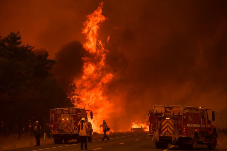
The Dixie Fire in California. After the devastating effects of the Dixie Fire across California, the Caldor Fire is gaining traction as it nears 100,000 in burning acres. AFP / Patrick T. FALLON
© Copyright IBTimes 2025. All rights reserved.
- MOST POPULAR IN National


