

Earthquake, Tsunami Danger In Pacific Northwest Likely Increased By Seafloor Sediments: Study
The Northwest Pacific region of the country faces an increased danger of both a devastating earthquake and a damaging tsunami, thanks to its location along the Cascadia Subduction Zone (CSZ), and the risk is enhanced by compact seafloor sediments, a study claimed Monday.
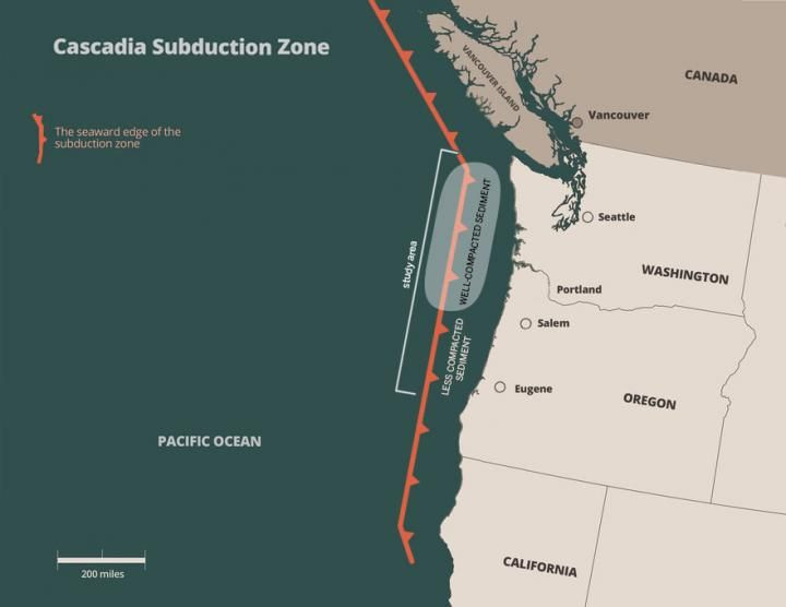
Led by the University of Texas, Austin, the study found that big earthquakes are more likely to occur off the coasts of Washington and Oregon, rather than further south, offshore northern California. The CSZ runs for about 1,000 kilometers (600 miles) off the coast of British Columbia, Canada, in the north down to the northern California coast in the south, between 70-100 miles away from the shoreline.
"We observed very compact sediments offshore of Washington and northern Oregon that could support earthquake rupture over a long distance and close to the trench, which increases both earthquake and tsunami hazards," Shuoshuo Han, a postdoctoral fellow at the University of Texas and lead author of the study, said in a statement Monday.
A subduction zone is a place where a tectonic plate slides under another, this phenomenon being called subduction. These areas are where powerful geological activity, such as earthquakes and volcano eruptions, occur around the world, to relieve the pressure built as a result of the subduction.
In the case of CSZ, 41 earthquakes have taken place here in the last 10,000 years, separated by as many as 1,200 years and as few as 190 years. The last major one in the region, its date traced due to a tsunami recorded in Japan, happened in January 1700, almost 320 years ago. That means, given our severe limitations in predicting seismic activity, scientists can only say "there is about a 40 percent chance that a megathrust earthquake of 9.0+ magnitude in this fault zone will occur in the next 50 years."
According to information available on the Oregon government website, such an earthquake could cause a "tsunami of up to 100 feet in height that will impact the coastal area."
During subduction, some of the sediment on the plate that goes under gets transferred to the top plate, where it piles up, forming a thick wedge over time. A seismic survey by Han and her fellow researchers found up to four miles of sediment layers over the subduction zone off the Washington and Oregon coasts. This sediment deposit was also found to be more compact than previously collected sediment samples.
These compact sediments have a dual effect on the destructive potential of the earthquake. One, the tight packing of grains makes the plates more likely to stick together, increasing the stress that will be released during the earthquake. Two, as the compact sediments move together during an earthquake, they can also shift larger amounts of water with them, leading to bigger tsunamis.
Titled "Links between sediment consolidation and Cascadia megathrust slip behaviour," the paper appeared online in the journal Nature Geoscience. Researchers from Columbia and Penn State universities also participated in the study.
© Copyright IBTimes 2025. All rights reserved.
- MOST POPULAR IN National


