

'Easy To Trigger' Avalanches Expected In Colorado, Utah; Storm Warnings Issued Across Northeastern Plains

KEY POINTS
- People can "easily trigger" destructive avalanches capable of damaging buildings
- Colorado witnessed two D3 avalanches Monday
- D3 avalanches are "very large" and can destroy small structures and facilities
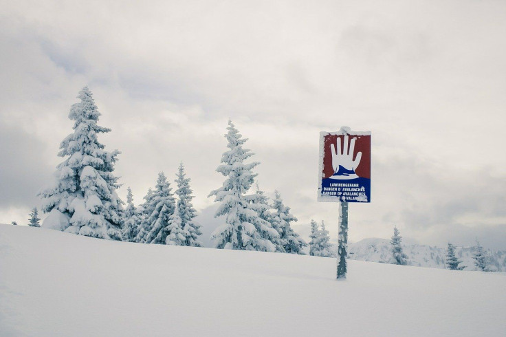
Parts of Utah and Colorado are in the high-level category for avalanche danger as the states continue to experience extreme snow events.
The Colorado Avalanche Information Center (CAIC) warned of "very dangerous avalanche conditions through Tuesday" and discouraged travel in the backcountry. It noted that the avalanche danger in the Central Mountains was "high" and urged residents to avoid all avalanche terrains in the area.
"You can easily trigger a large and destructive avalanche and some will release spontaneously," the office said.
#COAvalancheInfo Avalanche Warning for Park Range, Flat Top Mountains, Grand Mesa, Ruby Range, Uncompahgre Plateau, and San Juan Mountains. Very dangerous avalanche conditions through Tuesday. Travel in backcountry avalanche terrain is not recommended. https://t.co/E7yJWqyZwj pic.twitter.com/PMhXbXJF25
— CAIC:Statewide Info (@COAvalancheInfo) January 2, 2023
Aside from avalanche warnings, the National Weather Service (NWS) in Boulder also issued a winter storm warning for most of Colorado's northeastern plains.
A Winter Storm Warning is in effect for most of the northeastern plains now until 5 AM Tuesday morning for additional snowfall amounts of 3-6 inches. Prepare for hazardous travel as icy roads may become snow covered. pic.twitter.com/EP8gr7Gjch
— NWS Boulder (@NWSBoulder) January 3, 2023
The highest snowfall is expected in Phillips, Logan, Sedgwick, Washington and Morgan counties.
Officials said residents should expect "slick and hazardous" travel conditions from Monday evening as icy conditions are possible on the road. The office also warned avalanches can cause damage to buildings as they can run "all the way to valley floors."
Several avalanches were reported in Colorado on Monday, with three of them triggered by skiers. Two of them were D3 avalanches, which meant they had the capacity to "bury and destroy a car, damage a truck, destroy a wood frame house or break a few trees."
Avalanche sizes are measured through the D-scale, according to the Sierra Avalance Center. D1 avalanches are small but can "bury a person," while D2 avalanches are "large" and can injure people. D3 avalanches are "very large" and can destroy small structures and facilities. D4 and D5 avalanches are "historic" ones and could destroy an area of up to 40 hectares.
The Utah Avalanche Center said "people are likely to trigger large and dangerous avalanches" in the Logan area mountains, adding that residents should stay out of slopes steeper than 30 degrees. Avalanche danger was high at mid and upper elevations of the Ogden area mountains, while it was "considerable" in low elevation terrain.
Several avalanches were reported in Utah on Sunday, with one being labeled as "intentionally triggered."
The NWS in Salt Lake City has clarified the avalanche warnings do not apply to ski facilities as they follow hazard reduction measures.
⚠️Avalanche Warnings remain in effect for most Utah mountains until 6 AM Tuesday.
— NWS Salt Lake City (@NWSSaltLakeCity) January 2, 2023
Before heading to the backcountry, check in with https://t.co/r1Xq1EXzjf. Avalanche danger is HIGH is many areas today. #utwx pic.twitter.com/fY93fp8D2U
Alerts in Colorado
Avalanche warning effective through 11 p.m. Tuesday:
- Northwest San Juan Mountains, Southwest San Juan Mountains and Eastern San Juan Mountains above 10,000 feet (large and dangerous avalanches will be very easy to trigger)
Avalanche warning effective through 5 p.m. Tuesday:
- Flat Tops, Grand Mesa, Battlement Mesa, Gore and Elk Mountains, Dallas Divide, Central Mountain Valleys, West Elk Mountains, Sawatch Mountains, Uncompahgre Plateau, West Grand County above 9,000 feet and West Jackson County above 9,000 feet (very dangerous avalanche conditions)
Winter storm warning effective through 12 a.m. Tuesday:
- Arapahoe, Central and East Adams, North Lincoln, North and Northeast Elbert County below 6,000 feet
Winter storm warning effective through 5 a.m. Tuesday:
- Washington, Logan, Morgan, Sedgwick and Phillips (wind gusts as high as 35 mph possible)
- Northeast Weld County
Alerts in Utah
Avalanche warning effective through 6 a.m. Tuesday:
- La Sal and Abajo Mountains (avalanche danger high)
Avalanche warning effective through 6 a.m. Tuesday:
- Western Uinta Mountains, Wasatch Mountains south of I-80, Wasatch Mountains I-80 North, Wasatch Plateau, Southern Mountains, Central Mountains and Book Cliffs (very dangerous avalanche conditions)
© Copyright IBTimes 2025. All rights reserved.
- MOST POPULAR IN National


