

Hurricane Dorian Update: Dorian Continues Crawl Up East Coast, Georgia And South Carolina Face Worse Flooding
Hurricane Dorian continues its crawl up the East Coast and is expected to pound the Mid-Atlantic region through the end of the week.
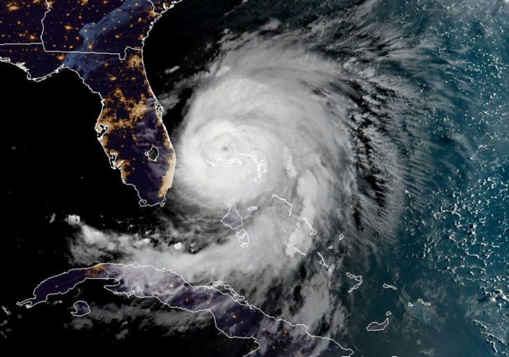
Dorian began making its slow crawl up the eastern seaboard Tuesday after a weekend that saw the Bahamas devastated by the Category 5 hurricane. Since then, Dorian has dropped back down to a Category 2 hurricane but is still threatening to thousands of residents living from the Florida coast to South Carolina.
Tracking from the National Hurricane Center placed Dorian’s heart off the coast of Jacksonville, picking up speed as it moves northwest. It has sped up from 2 mph on Tuesday to 8 mph on Wednesday morning with sustained winds of 105 mph. And despite the slow movement, the wind field has continued growing, with tropical storm winds reaching 175 miles from the eye of the storm.
As #HurricaneDorian spins less than 100 miles east-northeast of #DaytonaBeach, #Florida this morning, NOAA’s #GOES16 satellite is using its 1-km visible band to track where #Dorian is going next. Get the latest here NHC_Atlantic. #flwx #gawx #scwx #ncwx pic.twitter.com/JZKZWKs5cq
— NOAA Satellites - Public Affairs (@NOAASatellitePA) September 4, 2019
But the more pending threats for coastal communities are the heavy rainfall Dorian is bringing with it.
Flash flood warnings began being issued on Tuesday as coastal Florida began facing rainfall from the storm’s slow crawl. Warnings have since been issued as far north as Norfolk, Virginia, which is under a tropical storm watch and may last until Friday.
Georgia and South Carolina are expected to face the worse of the storm Wednesday.
Both states have been dealing with some coastal flooding from the storm’s edges, which is expected to worsen throughout Wednesday as Dorian passes Georgia.
© Copyright IBTimes 2025. All rights reserved.
- MOST POPULAR IN National


