

NASA Mexico Aerial Map Data Helps With Earthquake Recovery
The earthquake that rocked central Mexico on Tuesday has left a portion of the country in rubble. The 7.1 magnitude earthquake caused buildings to collapse and structures to become unsafe for use. In the following days there have been rescue efforts, some hindered by the damage so NASA has provided Mexico with satellite aerial data of the damaged areas to help in the assessment and rescue operations.
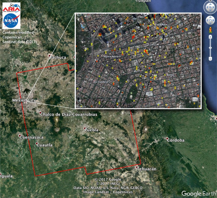
The researchers based at California Institute of Technology and NASA’s Jet Propulsion Laboratory worked to create the damage proxy map. The map is comprised of interferometric synthetic aperture radar satellite imagery, according to NASA.
The map compares data collected on Sept. 8, prior to the quake, to data taken on Tuesday a few hours after the earthquake hit. The images were taken from the Copernicus Sentinel-1A and Sentinel 1-B satellites that are operated by the European Space Agency. The photos were then provided to the Mexican authorities the day of the quake in the hopes that they could help in the recovery efforts.
The map of images covers about 100 by 100 miles of land and each pixel of it represents 33 yards, or 30 meters, says NASA. The map is now also available for anyone to download online. Essentially what it shows is how extensive the damage in a particular area was based on how much the image changed between the 8 and the 20 after the earthquake hit. The colors on the map represent the severity of the damage with yellow being less severe and red representing the most severe damage.
All of the data was processed by the NASA teams at CalTech and JPL by the Advanced Rapid Imaging and Analysis team that is funded by NASA. The team is working on creating automated system that can provide global positioning system and satellite data that can help with quick responses to disasters and support teams that provide hazard monitoring and response on local, national and international levels.
In addition to the work done by ARIA the NASA Disasters Program works with disaster response agencies worldwide to produce such critical information products like the map to help in disaster relief efforts. Similar maps were also provided by the National Oceanic and Atmospheric Administration following hurricanes Harvey and Irma.
The radar can measure through clouds day or night so the work ARIA does can be conducted at any time. This makes it especially ideal for natural disasters because they can sometimes be so unpredictable and need rapid responses, even if they happen in the middle of the night or on a cloudy day. The teams at CalTech and JPL also made a map following the 8.1 earthquake in Mexico on the coast earlier this month.
© Copyright IBTimes 2025. All rights reserved.
- MOST POPULAR IN Technology


