

NASA Shares Jupiter Storm Photo From Juno, The Gift That Keeps Giving

Winter storms have affected large parts of the East Coast the last few months, but even the largest storms on Earth don’t hold a candle to some of the enormous storms that rage across the face of Jupiter, the largest planet in the solar system. The gas giant has storms that last for hundreds of years which cover an area large enough to swallow up the whole of Earth.
Since NASA’s Juno spacecraft showed up in the vicinity of Jupiter in 2016 and entered a Jovian orbit on Independence Day that year, it has sent back several images that have allowed us to get a closer look at the largest storms in our immediate neighborhood.
NASA released a color-enhanced image of Jupiter’s north polar belt region Friday, which was processed using data collected by the JunoCam instrument on Juno.
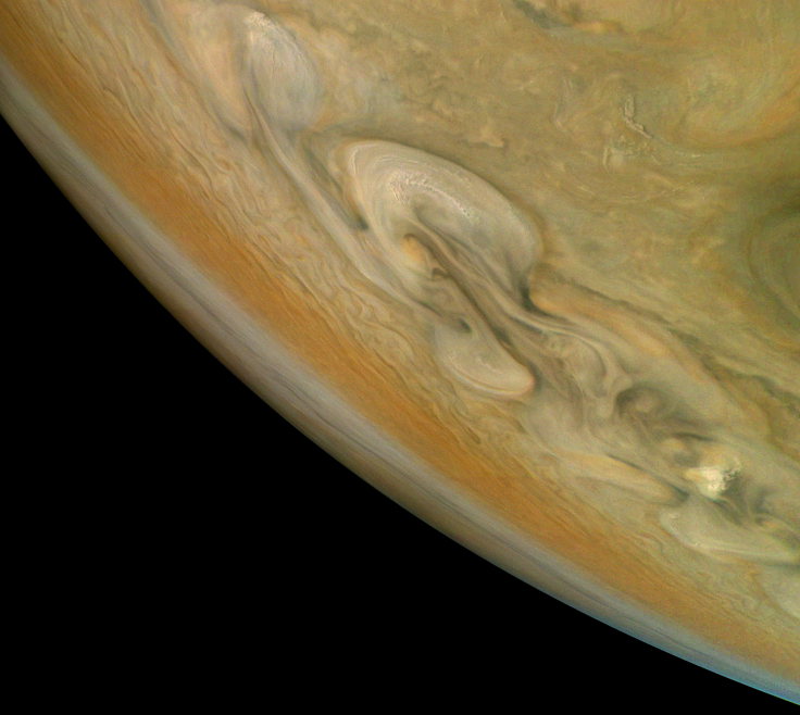
It shows a view from above the gas giant’s northern hemisphere, with the imager looking south. The broad swirls cutting diagonally across the planet are actually massive clouds moving about in cyclones in the planet’s thick atmosphere. At the time the image was taken (12:47 p.m. EST, Dec. 16), the spacecraft was about 5,600 miles above the planet’s cloud tops, at a latitude of 38.4 degrees north, during its tenth flyby of Jupiter, NASA said.
All images taken by Juno are available to the public. This image was processed from raw data by citizen scientist Björn Jónsson. Those interested in processing and producing such images can head over to this website.
On Dec. 19, NASA had shared another Juno image from its tenth flyby. It was a picture from the other side of the planet, when the spacecraft was almost directly over Jupiter’s south pole.
The image was captured from a distance of 64,899 miles from the top of Jupiter’s clouds, which would explain why so much more of the planet — an entire quarter — is visible in it, compared to the image of the north polar region. It was taken on the same day, Dec. 16, but an hour and 20 minutes later.
This image was also processed by a citizen scientist, Gerald Eichstädt. The various bands of colors seen in the image are different belts of clouds that have different chemical and physical properties. Each of these bands in Jupiter’s atmosphere is moving at hundreds of miles an hour, and is wider than Earth.
© Copyright IBTimes 2025. All rights reserved.
- MOST POPULAR IN Technology


