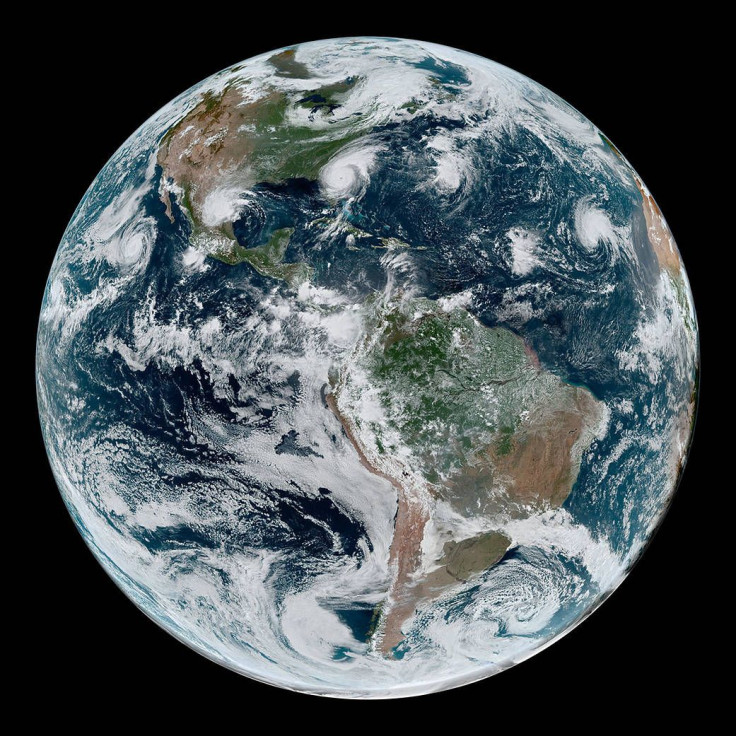
NASA Space Photo Captures 2 Hurricanes, 2 Tropical Storms Chained Along Western Hemisphere
Hurricane Dorian, now a Category 3 storm, is expected to move near the coast of North Carolina by Thursday evening or early Friday morning, said the National Hurricane Center (NHC) in one of its latest bulletins.
But Dorian isn’t the only bully in our neighborhood right now. NASA on Wednesday released satellite photos of one more hurricane plus two other tropical storms arrayed one next to the other and tearing through the Atlantic and Pacific Oceans.
This intimidating chain of tropical cyclones lined-up across the Western Hemisphere are frightening. A satellite photo taken 1:10 p.m. EDT on Sept. 4 shows Hurricane Juliette in the East Pacific and Hurricane Dorian in the Atlantic. Both were category 2 storms at the time.
Since then, Dorian has been upgraded to a category 3 as it wends its way through the Atlantic off the east coast of the U.S. The Carolinas are in Dorian’s sights.
In the Eastern Pacific, Juliette is moving northwest at 20 km/h (13 mph), some 1,200 km (765 miles) off the southern tip of Baja, California as of early Thursday morning. The category 1’s strength is expected to weaken over the next few days, said the NHC.
Juliette has maximum sustained winds of 137 km/h (85 mph) and is forecast to turn west on Saturday and continue on that path through the weekend. It is expected to become a tropical storm by Friday and a remnant low pressure area on Saturday.

Tropical Storm Fernand with sustained winds of 72 km/h (45 mph) at the time. Fernand made landfall in northeastern Mexico as a tropical storm at 11:35 a.m. CDT Wednesday. She has since weakened to a tropical rainstorm. She will rain itself out near the Rio Grande Valley and mountains to the west.
Tropical Storm Gabrielle strengthened into a tropical storm on Sept. 4 over the eastern Atlantic. She has sustained winds of 50 mph at the time of this image. She might become the next hurricane in the Atlantic Basin.
Forming off Africa’s West Coast, Gabrielle is forecast to drift westward across the tropical Atlantic throughout the week. It poses no immediate threat to land but might be of concern for shipping over the middle of the Atlantic during the middle to latter part of next week.
Data for the simulated natural-color image were acquired with the Advanced Baseline Imager on the Geostationary Operational Environmental Satellite (GOES) 16. GOES-16 is operated by NOAA.
NASA helps develop and launch the GOES series of satellites
© Copyright IBTimes 2026. All rights reserved.
- MOST POPULAR IN World