Tornado, Severe Thunder Storm Watch Issued For Parts Of Texas
The National Weather Service issued a new tornado warning for Panola County and surrounding areas in Texas until 4 a.m. local time (5 a.m. EDT) Thursday as heavy rain continued in the state.
The warning was issued at 8.45 p.m. local time (9.45 p.m. EDT), 45 minutes after the earlier-issued watch expired. The agency said a few tornadoes are likely, ping pong-sized hail were also possible with scattered gusts of winds up to 70 mph.
A line of thunderstorms “will continue to move through northern Louisiana and southern Arkansas, bringing the threat of damaging winds and isolated tornadoes. This line has a history of producing wind damage in Deep East Texas,” NWS said, Panola Watch Man reported.
A severe thunderstorm watch was also issued for the southern half of Panola County until 7:45 p.m. local time (8.45 p.m. EDT). Wind up to 60 mph and penny-sized hail were also expected.
The first storm warning issued Wednesday stated that a line of storms was likely to reach Houston sometime after 6 p.m. local time ( 7 p.m. EDT) which could produce severe wind gusts up to 60 mph, large hail, and minor street flooding.
CenterPoint Energy reported estimated 71,000 customers had lost power in Houston on Wednesday evening due to heavy rain and gusty winds.
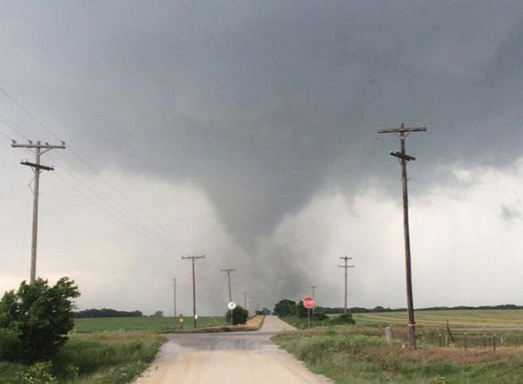
A tornado touched down near Eagle Lake on Wednesday afternoon, NWS confirmed. However, there is no clear picture yet about the damage caused by the twister. The Fort Bend County Sheriff's Office said they received several reports of another tornado touchdown on Agnes Road, however, there were no reports of damage or injuries. The Houston Fire Department too confirmed that they were responding to several weather-related calls for rising water and flooding.
"FD is responding to several weather related calls. We are responding to calls for rising water, flooding, and are actively working a swift water rescue call at Milby and Polk,” the fire department tweeted.
Once the storms clear Thursday morning, temperatures will be significantly cooler. The maximum temperature was at 75 degrees Wednesday, with lows reaching 59 degrees. The maximum temperature on Thursday is expected to be 60 degrees.
Tornado Alley armor reported that Texas has recorded the most number of tornadoes in the United States with 8,007 funnel clouds touching the ground between 1951 and 2011. On an average, the state sees 132 tornadoes each year. The greatest outbreak of tornadoes was associated with Hurricane Beulah in September 1967 during which 115 known tornadoes touched the Texas soil in a period of five days.
© Copyright IBTimes 2026. All rights reserved.
- MOST READ