

Weather: Over 30 Areas Under Flood Watch As Another Atmospheric River Affects California

KEY POINTS
- The heaviest rainfall in Los Angeles is expected Monday evening
- Guadalupe River could exceed flood stage by Monday night
- Up to 12 inches in rainfall totals is possible in Santa Barbara County
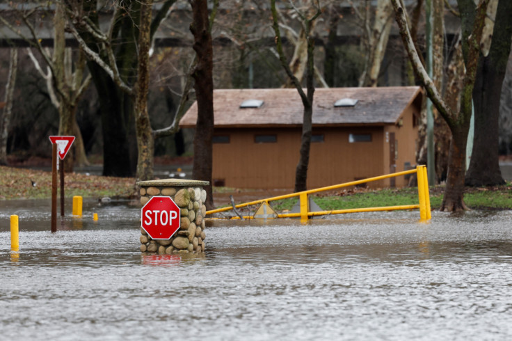
More than 30 areas across California have been placed under a flood watch and a few areas are under flood warnings as another atmospheric river is expected to hit the state through Tuesday.
"A barrage of atmospheric rivers continues to impact the West Coast with the next system set to sweep into California tonight. Heavy rain is expected to add up to several inches across much of central California through Tuesday," the National Weather Service (NWS) said in its Short Range Public Discussion report Sunday.
An atmospheric river is a filament of concentrated moisture flowing from the ocean that releases water vapor in the form of snow or rain. The National Oceanic and Atmospheric Administration (NOAA) describes atmospheric rivers as similar to "rivers in the sky" that pack average waterflow roughly equivalent to water amounts at the mouth of the Mississippi River.
Officials at the NWS in San Diego noted that rain showers are expected to develop as early as Monday morning in northern areas before spreading farther south Monday evening.
(2/8) Scattered showers will be possible as early as Mon morning across northern areas & will spread to the southeast by Mon night. The heaviest/most widespread rain will occur Tue morning/afternoon, and flooding will be possible. T-storms will also be possible during this time. pic.twitter.com/BBg7hH7koo
— NWS San Diego (@NWSSanDiego) January 8, 2023
Thunderstorms are possible Tuesday when the heaviest and most widespread rainfall affects the state, officials said.
The NWS in Los Angeles also said it is expecting up to nine inches of rainfall totals in California's foothills and mountains and up to 12 inches on south-facing slopes.
Total rainfall expected tonight through Tuesday. 2-5" coast/vlys and 5-9" foothills and mtns. Local up to 12" with highest amounts on the S facing slopes. #cawx #LARain #LAWeather #SoCal pic.twitter.com/8TodqtNUdZ
— NWS Los Angeles (@NWSLosAngeles) January 8, 2023
The heaviest rainfall is expected in Ventura, Santa Barbara and San Luis Obispo Monday afternoon, while Los Angeles is forecasted to get the heaviest rainfall Monday evening.
Here is the latest rainfall timing and intensity expected across SW CA from the major storm tonight through Tuesday. #cawx #LAWeather #LARain #SoCal pic.twitter.com/CwcJBIDoJB
— NWS Los Angeles (@NWSLosAngeles) January 8, 2023
Damaging winds will accompany the heavy rainfall through Monday, the NWS in Sacramento said, with some areas like Sacramento and San Francisco possibly seeing wind gusts of up to 60 mph.
Damaging winds will return again later this evening through tomorrow as the next winter storm arrives to interior #NorCal.
— NWS Sacramento (@NWSSacramento) January 9, 2023
Expect widespread power outages, downed trees and difficult driving conditions.
Now is the time to prepare if you have not already! #CAwx pic.twitter.com/uyDfClarYs
Flood warnings effective until further notice:
- Carmel River at Robles Del Rio (river could possibly exceed flood stage of 8.5 feet by 6 p.m. Monday)
- Guadalupe River above Almaden Expressway (river could exceed flood stage of 9.5 feet by late Monday afternoon)
Flood warning effective through 10 p.m. Monday:
- Russian River near Hopland (river could possibly exceed flood stage of 15 feet Monday afternoon)
Flood watches effective through 8 a.m. Monday:
- Southern Humboldt Interior
- Sonoma coastal range, North Bay interior mountains and valleys, and coastal North Bay including Point Reyes National Seashore
- San Francisco Bay Shoreline
Flood watches effective through 10 a.m. Monday:
- Southwestern Humboldt
- Northern and southern Lake County
- Northeastern, southeastern, southwestern and northwestern Mendocino Interior
- Mendocino Coast
- Southern Trinity
- San Francisco Peninsula Coast, East Bay Hills and interior valleys, Santa Cruz Mountains, Santa Clara Valley including San Jose, Eastern Santa Clara Hills, Lake San Antonio, Big Sur Coast, southern Monterey Bay, Arroyo Seco, southern Salinas Valley
- Shasta Lake Area, northern Sacramento Valley, northern Shasta County
Flood watches effective through 2 p.m. Monday:
- Santa Barbara County, including Alisal burn scar (up to 12 inches in rainfall totals possible)
- Motherlode, Carquinez Strait and Delta, southern and central Sacramento Valley, northern San Joaquin Valley
Flood watches effective through 4 p.m. Monday:
- Los Angeles County, including Dam, Bobcat, Ranch2, Lake, Fish, Palisades, Tumbleweed, North and Route burn scars (up to 9 inches in rainfall totals possible in the mountains and foothills of the San Gabriel range)
- National Monument, northern Monterey Bay, Mountains of San Benito County, Interior Monterey County including Pinnacles, Los Padres National Forest and Santa Lucia Mountains
- Buena Vista, Tehachapi, West Side Mountains South of 198, Grapevine, Los Banos to Dos Palos, Piute Walker Basin, Caruthers – San Joaquin – Selma, Coalinga – Avenal, Delano – Wasco – Shafter, Fresno – Tulare Foothills, Fresno – Clovis, Hanford – Corcoran – Lemoore, Mariposa Madera Foothills, West Side of Fresno and Kings Counties
Flood watches effective through 6 p.m. Monday:
- Malibu Coast, Los Angeles County beaches, Santa Clarita Valley
- The southeastern and southwestern coast of Santa Barbara County
Flood watches effective through 10 p.m. Monday:
- Ventura County, including Ojai Valley, Ventura County Inland Coast, Ventura County Mountains, Lake Casitas, southeastern Ventura County Valleys, Central Ventura County Valleys
- San Luis Obispo County, except Carrizo Plain
- Santa Ynez Valley, Santa Ynez Mountains Eastern and Western Ranges, Santa Barbara County Inland Central Coast, Santa Barbara County Interior Mountains
- Santa Monica Mountains, Los Angeles County San Gabriel Valley, Los Angeles County Inland Coast including Downtown Los Angeles
- Marin Coastal Range
Flood watch effective from Monday evening through 4 p.m. Tuesday:
- Los Angeles County Mountains
Flood watches effective through 8 p.m. Tuesday:
- Antelope Valley
- Santa Ana Mountains and Foothills, San Gorgonio Pass near Banning, Riverside County Mountains
- Mountains Southwestern Shasta County to Western Colusa County
Flood watches effective through 10 p.m. Tuesday:
- Hollister Valley
- Carmel Valley
- San Bernardino and Riverside County Valleys – the Inland Empire and Orange County Coastal and Inland
Flood watch effective through 4 a.m. Wednesday:
- Yosemite Valley, Sequoia NP, Kaiser to Rodgers Ridge, Grant Grove Area, San Joaquin River Canyon, Kern River Valley and South End of the Upper Sierra
Flood watch effective through 6:45 a.m. Wednesday:
- Bear Creek above Mckee Road (river could reach flood stage of 23 feet by late Monday afternoon)
© Copyright IBTimes 2025. All rights reserved.
- MOST POPULAR IN National


