

Buffalo Snowstorm Pictures 2014: Second Lake Effect Storm To Hit New York [PHOTOS]

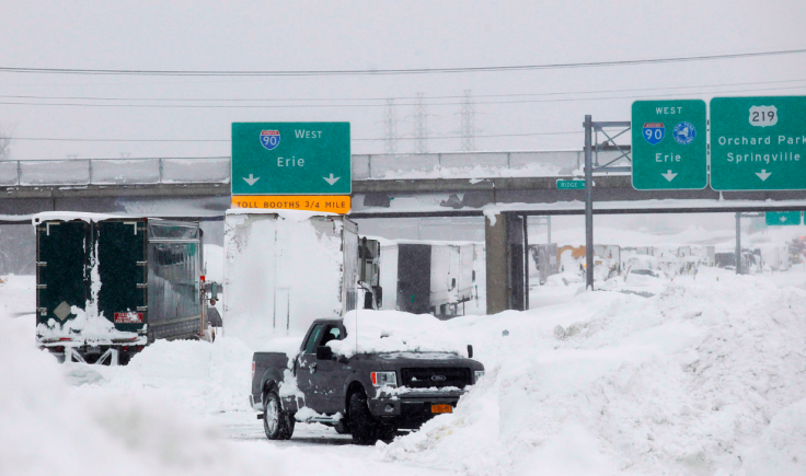
As if 65 inches of snow weren’t enough, western New York state is slated to face a second round of lake effect snow, the Buffalo News wrote Wednesday. The storm is supposed to begin about 11 p.m. Wednesday and last until Friday afternoon.
Niagara Falls, New York, has already reportedly been hit with some of the new snow, the National Weather Service Buffalo tweeted Wednesday. The Twitter account shared a series of pictures to depict the mammoth snowfall that the Buffalo area has faced this week.
Aerial snowstorm photos from @DerekGeePhoto. Keep checking our gallery as we add more pictures http://t.co/qldICTby5J pic.twitter.com/KzYCF33rOi
— The Buffalo News (@TheBuffaloNews) November 19, 2014In Depew, they starting to dig themselves out -- with dustpans http://t.co/hsPAr6TgVZ (@DerekGeePhoto) pic.twitter.com/YOaI6P6eZW
— The Buffalo News (@TheBuffaloNews) November 19, 2014Snow engineering RT @WxDeFlitch: How about this for creativity in Lackawanna, NY posted to @WGRZ FB page #NYwx pic.twitter.com/D2JpxcpjAL"
— Eric Fisher (@ericfisher) November 19, 2014A quick reminder: It’s not even officially winter, which begins Dec. 21.
New York Gov. Andrew Cuomo has been active on Twitter since western New York became inundated with snow. The governor, who is lodging in Buffalo for the night, has reportedly oversaw snow removal operations and has advised people remain indoors since it's “treacherous” out there.
The governor shared a series of pictures on his Flickr account; they shows the time he has spent in western New York so far. Click here to view the photos.
Photos of today's tour and briefing of storm conditions in Western New York. https://t.co/px9hqUwgrK #BuffaloSnow pic.twitter.com/bxVyoUjhWP
— Andrew Cuomo (@NYGovCuomo) November 20, 2014Cuomo told Time Warner Cable News in Albany that all this snow could break records that have been held for more than 100 years. "Buffalo is very good at handling snow, but this may break, literally, records that have been in existence for over 100 years,” Cuomo said. "A lot of snow is one of the understatements of all time.”
As far as making sure there were enough workers and equipment to handle the immense snow removal, he said it would probably be the “largest deployment” ever. And even though it will be “very difficult,” he added, “This is what New York does best.”
A state of emergency was declared for 10 counties in western New York. At least seven people have died from the fatal storm.
The severe weather is supposed to subside over the weekend.
Incredible pictures from near Buffalo, NY. 5 feet of snow in some spots! #LakeEffect #BuffaloSnow #nywx. pic.twitter.com/fOn3xuoM6D
— NWS Binghamton (@NWSBinghamton) November 19, 2014This pic doesn't look like much until you notice that this is actually a street... with snow up to the mailboxes. pic.twitter.com/IA48dpIgad
— Trending Buffalo (@TrendingBuffalo) November 19, 2014Hermine Kolb in Winchester sent us this photo. Click here for the latest storm updates: http://t.co/H6eD2yStgn pic.twitter.com/uiWkb36jjT
— WIVB News 4 Buffalo (@news4buffalo) November 19, 2014An *astonishing* amount of snow -- Cheektowaga, NY has accumulated 65 inches of #LakeEffect. http://t.co/iQBpgmoJoS pic.twitter.com/EkoU0bFiXV
— Capital Weather Gang (@capitalweather) November 19, 2014SO MUCH SNOW. Cheektowaga, NY. Credit Kassie Tamulski. #lakeeffect pic.twitter.com/j4rETbcGbm
— The Weather Channel (@weatherchannel) November 19, 2014Car this morning. Impossible to drive pic.twitter.com/pfW713Y6b4
— Deon Broomfield (@iBroomy) November 19, 2014RT @dynamodreams: #wgrzsnow neighbors house in cheektowaga #WGRZsnow pic.twitter.com/GA6783kELb
— The Weather Channel (@weatherchannel) November 19, 2014Shoveling out in south Buffalo. Some progress. #lakeeffect Posted by Nick D'Angelo to WIVB. pic.twitter.com/2h4H2rycje
— The Weather Channel (@weatherchannel) November 19, 2014House looks like it's smiling but under weight of snow, probably not. #lakeeffect RT @confusedcaboose: pic.twitter.com/gyWTIKW27j
— The Weather Channel (@weatherchannel) November 19, 2014Follow me on Twitter @mariamzzarella
© Copyright IBTimes 2026. All rights reserved.
- MOST READ


