

California Floods: Another 'Large Cyclone' Threatens State As Thousands Remain Under Evacuation Orders

KEY POINTS
- A winter storm that hit the western U.S. brought heavy rains to California on Tuesday
- Further flooding is expected as the soil is "saturated from heavy rainfall"
- Some rivers are expected to exceed or reach flood stage
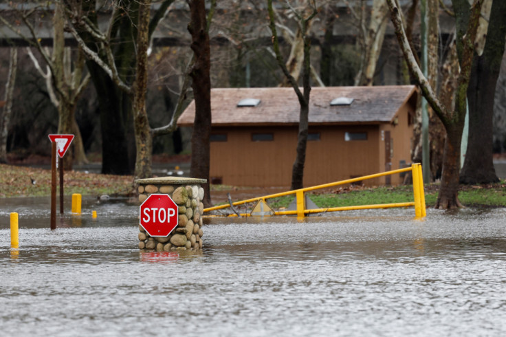
California has been hit with a barrage of atmospheric rivers since Christmas, and now another "large cyclone" is headed to the flood-plagued state. The cyclone will slam into the Pacific coast Wednesday, forecasters warned.
A winter storm that hit the western U.S. brought heavy rains to California and its neighboring states Tuesday evening.
Almost 49,000 people were under evacuation orders in California as of Tuesday, which included residents living along the Carmel and Salinas rivers, the New York Times reported.
"Moisture will stream ahead of a large cyclone in the eastern Pacific Ocean, which will produce heavy precipitation in northern California," the National Weather Service (NWS) said in a report Tuesday.
The weather agency noted that soils in California "are saturated from above average rainfall over the past few weeks, which means it won't take much additional rainfall to trigger flooding."
🌧️ Showers and isolated thunderstorms are still possible this evening. Another round of precipitation will move through later tonight into Wednesday. Here is a look at the potential timing. #CAwx
— NWS Sacramento (@NWSSacramento) January 11, 2023
Forecast: https://t.co/WjKBsJmSfA
Roads: https://t.co/6jnhwJwK5a pic.twitter.com/zFYkEOLQIL
Snowfall continued over the mountains in Sacramento on Tuesday evening, making travel difficult in affected areas.
Snow will continue this evening over the mountains. Expect travel delays and chain controls overnight if traveling into the mountains. For more information on road conditions you can go to https://t.co/wAigFjqlOB #CAwx pic.twitter.com/U5oTPQlJXl
— NWS Sacramento (@NWSSacramento) January 11, 2023
In some areas, up to 22 inches of snow and wind gusts of up to 35 mph are possible. It could lead to road closures and extensive tree damage.
The NWS Bay Area shared a satellite view of the "large area of low pressure" in the Pacific, which is expected to be the "next rain maker" in California.
Satellite🛰️showing a large area of low pressure out over the Pacific. This will be our next rain maker tomorrow (Wednesday).#cawx pic.twitter.com/ERcUQijP9X
— NWS Bay Area 🌉 (@NWSBayArea) January 11, 2023
Authorities have issued flood warnings and watches in areas that are expected to be affected by Wednesday's rains.
Flood warning effective until further notice:
- Monterey – Salinas River near Spreckels (river expected to continue rising to 29.4 feet by Wednesday night)
Flood warning effective through 6 a.m. Friday:
- Mendocino – Russian River near Hopland (river expected to exceed flood stage of 15 feet early Thursday morning)
Flood warning effective through 11.30 a.m. Wednesday:
- Merced – Bear Creek above Mckee Road (creek expected to exceed flood stage of 23 feet Tuesday evening)
Flood advisory effective through 2 p.m. Wednesday:
- Sonoma
Flood watch effective through 2 p.m. Wednesday:
- Shasta Lake area and northern Shasta County
Flood watch effective through 4 a.m. Wednesday:
- Yosemite Valley, Sequoia NP, Mojave Desert slopes, Grapevine, Frazier Mountain communities, Grant Grove, Kaiser to Rodgers Ridge, Kern River Valley, San Joaquin River Canyon, Piute Walker Basin, Tehachapi
Flood watch effective through Wednesday noon:
- Motherlode, northeast Foothills, Sacramento Valley, and mountains southwestern Shasta County to western Colusa County
Flood watch effective through 2 p.m. Friday:
- Humboldt Coast – Eel River at Fernbridge (river expected to reach flood stage of 20 feet by late Thursday evening)
Winter storm warning effective through 4 a.m. Wednesday:
- Sierra Nevada above 6,000 feet from Yosemite National Park to Tulare County
Winter storm warning effective through 4 a.m. Wednesday:
- West Slope Northern Sierra Nevada and western Plumas County, Lassen Park (up to 22 inches of snow accumulations possible)
© Copyright IBTimes 2025. All rights reserved.
- MOST POPULAR IN National


