

Strong Earthquake In Gulf Of Alaska Prompts Tsunami Warning Along West Coast
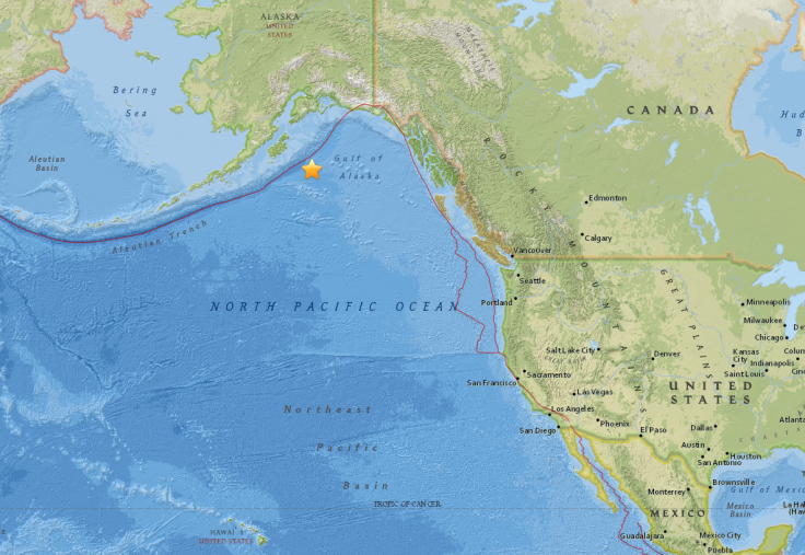
The U.S. Tsunami Warning System issued notices early Tuesday morning for Alaska, Hawaii and states along the West Coast, after a strong earthquake struck 280 kilometers southeast of Kodiak, off the coast of Alaska, at about 4:30 a.m. EST.
The agency, part of the National Oceanic and Atmospheric Administration, said a tsunami warning was in effect for parts of Alaska, including the Aleutian Islands. It was south and southeast Alaska, and the Alaska Peninsula that were at the greatest risk, while Anchorage, given its strategic location, was out of the danger zone.
ATTN: There is no TSUNAMI Warning for the Anchorage area and Vicinity. We are *outside* the danger zone. https://t.co/isUm6F35XG
— Anchorage Police Department (@AnchoragePolice) January 23, 2018
The notice also said a tsunami watch was in effect for all three U.S. states along the West Coast — Washington, Oregon and California — as well as British Columbia in Canada. Another notice by the agency also said a tsunami watch was in effect for the whole of Hawaii.
A buoy, part of the warning system, registered a 32-foot rise in the water level near the earthquake’s epicenter. According to the U.S. Geological Survey, the earthquake had a 7.9 magnitude, with its epicenter at a depth of 25 kilometers.
Here is the buoy which reported a 32 foot water rise shortly after the powerful 8.2 magnitude earthquake just south of Alaska. #TsunamiWarning Alaska and Canadian West Coast pic.twitter.com/TJgipkZ3qk
— Bill Karins (@BillKarins) January 23, 2018
The National Weather Service’s (NWS) warning system in Alaska seemed to be working well, with some locals receiving alerts immediately.
NWS in the Bay Area in California also issued an alert.
A Tsunami Watch is in effect for California, the Coast from the Cal/Mexico Boarder to the Oregon/Cal Border including the San Francisco Bay. Updates will be provided as soon as we have them#CAwx
— NWS Bay Area 🌉 (@NWSBayArea) January 23, 2018
If you are in an area that could be affected by a tsunami (check here and here to see if you are), you should evacuate either to higher ground or farther inland, away from the coast. Definitely leave the designated tsunami hazard areas, or move to a higher floor of a tall building, if you can’t evacuate. Stay away from the shore, be it a marina or a bay or a beach or a harbor. Do not try to go closer to the shore to observe the tsunami. Return to an area near the coast only when asked by local authorities to do so.
This is a developing story.
© Copyright IBTimes 2025. All rights reserved.
- MOST POPULAR IN National


