

Tropical Storm Sally Expected To Hit Near New Orleans As A Hurricane
KEY POINTS
- Tropical Storm Sally is bearing down on Lousiana and is expected to make landfall near New Orleans
- The city, which was devastated by Hurricane Katrina in 2005, is now protected by a new levee system
- Sally will put this system to another test with 7 to 11 feet of storm surge expected
The National Hurricane Center (NHC) says Tropical Storm Sally will strengthen to either a Category 1 or 2 hurricane over the Gulf of Mexico on Monday before making landfall Tuesday near New Orleans.
In its Sunday evening bulletin issued 11 p.m. EDT, the NHC reported, "Sally is forecast to become a hurricane on Monday, with some additional strengthening possible before the center crosses the northern Gulf Coast."
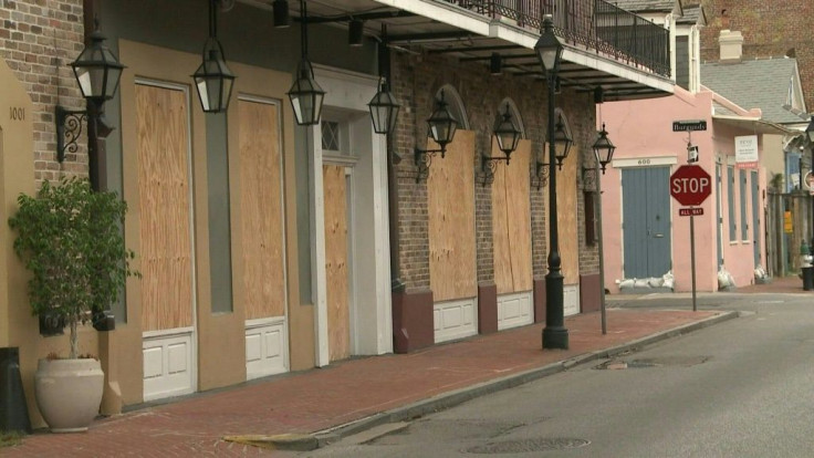
New Orleans Mayor LaToya Cantrell on Sunday issued a mandatory evacuation order for residents outside of the city's levee protection system. She said water pumps are in place and operational, and sandbags are available for residents throughout the city.
The NHC issued a hurricane warning for the next 36 hours for parts of Mississippi and Louisiana as Sally is expected to inundate both states in more than a water. The latest report saw Sally with maximum sustained winds of 60 mph, but she will likely become a hurricane with winds approaching 100 mph by landfall.
The NHC said a hurricane warning is also in effect from Morgan City, La., to Ocean Springs, Miss. The same warning covers Lake Pontchartrain and Lake Maurepas in Louisiana, including metropolitan New Orleans. A hurricane warning means hurricane conditions are expected somewhere within the warning area. There is a hurricane watch for the east of Ocean Springs to the Alabama/Florida border.
A storm surge watch is in effect for the Mississippi/Alabama border to the Alabama/Florida border. Storm surges of up to 7 to 11 feet are possible near the center of the storm and east of where landfall is expected.
A storm surge warning is also in effect at Port Fourchon, Louisiana to the Mississippi/Alabama border, as well as Lake Pontchartrain, Lake Maurepas, and Lake Borgne in southeastern Louisiana. This means there will be a danger of life-threatening inundation from storm surge within the warning area over the next 36 hours.
Sally is expected to strengthen and slow down slightly, bringing with it life-threatening storm surge, hurricane-force winds, and heavy rainfall along portions of the Gulf Coast starting Monday.
As of Sunday evening, Sally was moving at a slow 9 mph toward the west-northwest and is expected to continue along this course throughout the evening. It's expected to turn to the northwest Monday night and Tuesday.
On its current forecast track, Sally's center will move over the north-central Gulf of Mexico Sunday evening and Monday. Sally is expected to move slowly northward near the southeastern Louisiana or Mississippi coasts through Tuesday.
On Saturday evening, Louisiana Gov. John Bel Edwards declared a state of emergency. He said the government has every reason to believe Sally represents a very significant threat to the people of southeast Louisiana.
"While we ultimately don't know where Sally will make landfall, much of Southeast Louisiana is in the storm's cone and the risk of tropical storm force or hurricane strength winds continus to increase. This storm has the potential to be very serious," said Edwards.
Mississippi Gov. Tate Reeves on Sunday signed a preliminary state of emergency, saying he expected to Sally to "persist over most portions of the state for basically 48 hours." Both governors have sent pre-landfall federal declaration request to President Donald Trump.
© Copyright IBTimes 2025. All rights reserved.
- MOST POPULAR IN National


