

Wisconsin Weather: Flash Flood, Severe Thunderstorm Warnings Issued, Power Outages Reported
The National Weather Service issued flash flood and severe thunderstorm warnings for parts of Wisconsin after storms moved through the area Sunday evening, causing heavy rain.
A flash flood warning was issued for northern Milwaukee County and southern Ozaukee County till 2 a.m. local time (3 a.m. EDT) Monday morning. The counties witnessed 2-4 inches of rain Sunday evening.
Severe thunderstorm warnings were issued for east-central Wisconsin on Sunday night.
"A line of strong to severe thunderstorms will continue to move across east-central WI through the evening hours. The strongest storms will produce wind gusts to around 50-60 mph and small hail. This activity will also produce torrential rainfall which could lead to some flooding,” the weather agency tweeted.
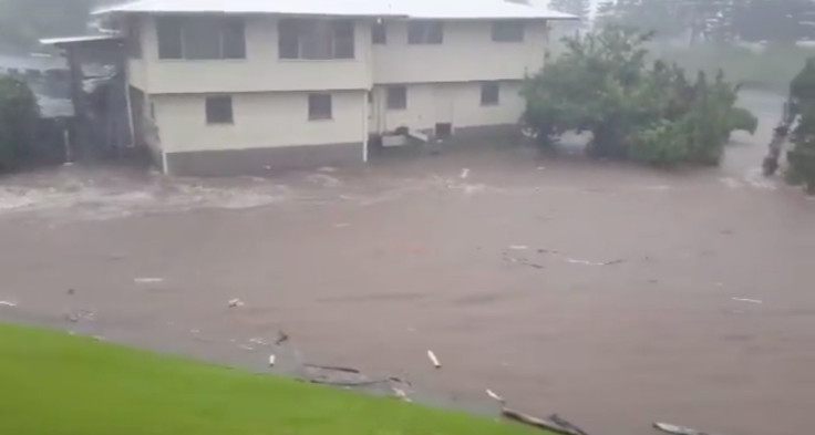
Madison, an area rocked by flooding last week, could get 2.19 inches rain through Tuesday night while around 1.79 inches is forecast in Milwaukee.
Power outages were witnessed throughout southeastern Wisconsin on Sunday evening, affecting about 3,100 customers in Milwaukee County, 1,300 in Waukesha County, 1,800 in Jefferson County, 600 in Washington County and 1,300 in Ozaukee County.
Wind-related damages were reported in Jefferson County on Sunday night.
“Please stay alert to the weather conditions Sunday and Monday night, and be aware flooding is possible. Don't drive through flooded roads, always remember the road may be washed out,” FOX 11 chief meteorologist Patrick Powell said.
“Rain and storm chances will even continue into Tuesday, before a strong cold front approaches Tuesday night. Once the cold front passes by Wednesday, much cooler air (daytime temperatures in the 60s/70s) will follow, along with a drying trend the rest of the workweek,” Meteorologist Blake Hansen said.
A tornado warning was issued for Washington County, Ozaukee County and parts of central Wisconsin, including Columbia County on Sunday evening; however, it was canceled later. A few wind damages were reported from the counties but no tornado was reported.
Over 500 lightning strikes occurred Sunday evening and in addition, there were reports of trees down, and some smaller hail, CBS58 reported.
Last week, several parts of Wisconsin witnessed about 11 inches of rain. Dane County was one of the worst hit areas with about 1,068 individual reports of private property damage. According to Dane County officials, the damages in the area exceeded $100 million.
Following the heavy flooding last week, officials with the city of Madison added more homes to the flash flood risk areas Sunday in anticipation of more flooding.
“Updated maps show new risk areas for flash flooding during an intense rainstorm. Approximately 1,200 homes have been added to the flash flood risk areas. Flyers will be distributed to these homes on Monday, August 27,” the officials said in a statement.
Officials also said the houses are near storm drains that empty into lakes. This could pose a major concern for flash flooding in severe weather, Channel 3000 reported.
© Copyright IBTimes 2025. All rights reserved.
- MOST POPULAR IN National


