

Denver Experiences Winter Storm Two Days After Blistering Heat
The National Weather Service issued a winter storm advisory for Denver today, with temperatures plunging to 32 degrees following a weekend of 100-degree temperatures.
Temperatures were in the 90s as recently as Monday. Massive temperature swings are not uncommon in the tumultuous Colorado climate, and the shift will need to be at least 61 degrees to make it into the top five most extreme temperature changes on record.
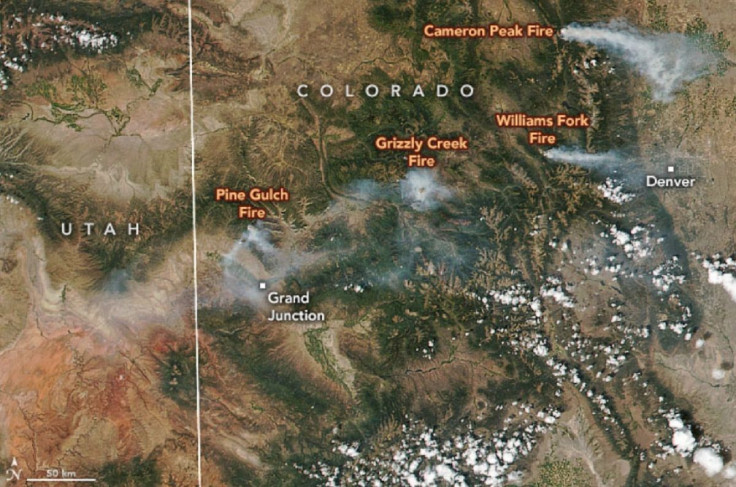
The drop may come as a relief to some residents. The predicted 8- to 10-inch snowfall is expected to dampen or extinguish the wildfires currently raging in the region. Those fires have grown to almost 90,000 acres at Cameron Peak, fed by hot and dry conditions.
Traction Laws in Colorado; what you need to know to avoid a fine https://t.co/uivopylgAG
— Channel 2 KWGN (@channel2kwgn) September 8, 2020
Snow Snaps: Share your photos from early September storm https://t.co/UYX2xLwCPH
— Channel 2 KWGN (@channel2kwgn) September 8, 2020
Hello SNOW ❄️ this is in Loveland right now. @channel2kwgn pic.twitter.com/7ufjhGyIg0
— Natalie Tysdal (@NatalieTysdal) September 8, 2020
A weather forecast from KDVR shows below freezing temperatures persisting up through Thursday before slowly climbing back up over the rest of the week. Images from their website showed a light mix of snow and rain, expected to progress exclusively to snow tonight.
The early arrival of winter could have an effect on fall leaf coloration, dampening the hues from reds and oranges into browns. Dan West, a state forest entomologist for the Colorado State Forest Service, told the Denver Post sudden sub-freezing temperatures could damage the trees.
“It’s definitely going to affect the amount of fall foliage that we see this season,” West said. “We’re likely to see quite a bit of loss of color. Instead of seeing the yellows and the oranges, we’re instead going to see more of a brown effect.”
© Copyright IBTimes 2025. All rights reserved.
- MOST POPULAR IN National


