

Extreme Weather 2020: Hurricane Center Tracking 5 Tropical Waves Across Atlantic
KEY POINTS
- The National Hurricane Center was tracking three tropical disturbances between the Carolina coastline and Gulf of Mexico
- Two of the disturbances are being closely monitored heading into the weekend for their potential growth
- Tropical Storms Paulette and Rene continued churning in the open Atlantic Ocean as they moved westward toward the East Coast
As two tropical storms churned out in the open Atlantic Ocean, the National Hurricane Center was tracking three tropical disturbances Thursday that formed off the U.S. coast.
The most pressing of these disturbances formed off the coast of the Carolinas and was detected around 8 a.m. Thursday. The NHC said given its proximity to the Carolinas’ coastline it’s unlikely to form into anything stronger. However, communities along the coast should be prepared for possible scattered and heavy rainfall, strong storms, and strong winds.
“A trough of low pressure located just off the coast of North Carolina is producing minimal shower and thunderstorm activity,” the NHC reported Thursday. “This system is expected to move inland over eastern North Carolina this afternoon, and therefore significant development is not expected.”
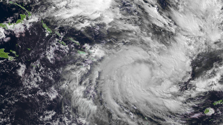
The next tropical disturbance formed northeast of the central Bahamas. It is currently described as “a large area of disorganized showers and thunderstorms” moving west towards the Gulf of Mexico. The NHC said the front will hit multiple islands in the Bahamas and southern Florida on its way to the gulf, where conditions will be more ideal for the storm to grow over the weekend.
“Upper-level winds are expected to become conducive for some development of this system while it moves slowly west-northwestward over the eastern Gulf of Mexico early next week,” the NHC said.
Third is a disturbance that formed in the Gulf of Mexico.
“Another trough of low pressure has developed over the northeastern Gulf of Mexico and is producing a few disorganized showers and thunderstorms,” the NHC said. “Some slow development of this system is possible while this system moves westward and then southwestward over the northern and western Gulf of Mexico through early next week.”
As for Tropical Storm Paulette and Tropical Storm Rene, the pair continued churning out in the open ocean as they slowly marched west-northwest toward the U.S.
Paulette presents the most immediate threat of the two storms due to the rate it is growing. It’s forecast to reach hurricane-strength by Tuesday and the NHC’s projected path has it moving up the U.S. East Coast, though it’s not clear where it could end up hitting if it does reach the U.S.
However, Paulette’s path would have it hitting Bermuda sometime in the next week.
Rene, on the other hand, looks likely to remain out in the open ocean. Between the two storms, it was slower to develop and remains a smaller storm when compared to Paulette. The NHC’s forecast has it briefly strengthening to a hurricane over the weekend before almost immediately dropping back down to a tropical storm.
© Copyright IBTimes 2025. All rights reserved.
- MOST POPULAR IN National


