

Extreme Weather: Blizzard Conditions Shut Dozens Of Roads And Highways In Dakotas, Wyoming

KEY POINTS
- U.S. 12 is 'solid ice,' South Dakota highway patrol said
- 85 miles of I-29 is also closed to traffic, transportation officials said
- I-25 between Douglas and Glenrock in Wyoming is also closed
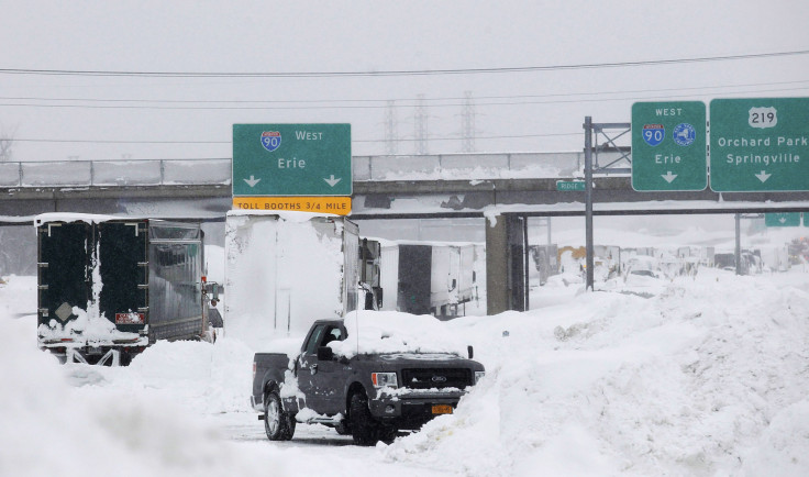
More than a hundred miles of Interstate 90 have been shut down indefinitely due to blizzard conditions in South Dakota and some of its neighboring states in the Northern Plains. Transport officials have warned that closure may last for days.
"I-90 from Rapid City to Murdo and I-29 from Watertown to the North Dakota border are closed," the South Dakota Department of Transportation (SDDOT) said in an alert on its website late Tuesday. "No vacancies in Murdo. Adjust travel plans and seek shelter elsewhere. Expect multiple day closures," the SDDOT said.
The closures cover more than 140 miles of I-90 and about 85 miles of I-29, as per CNN. The highway patrol also warned that U.S. 12 near Summit, South Dakota was "solid ice and hard to even walk on," making the route "impassable."
The Pennington County Sheriff's Office said Sage Creek Road "is totally blocked." The office also posted a photo of a truck that tried to get around the I-90 closure but got stuck instead. "Even if roads and weather look improved, they are not," the office reiterated.
NO TRAVEL ADVISED in Pennington County! Sage Creek Road is totally blocked. This truck got stuck using a side road to get around closure of Interstate 90. Even if roads and weather look improved, they are not. Stay safe. Stay inside. pic.twitter.com/o26b9b9BCq
— Pennington County SO (@PennCoSheriff) April 4, 2023
While the winter storm is expected to wind down across Rapid City, gusty winds are still possible through Wednesday. Blizzard conditions are still expected in some parts of the state including Onida, White River, Mission, Union Center, Dupree, Martin, Wall and Philip, the NWS in Rapid City said.
9 pm MDT Update - We've downgraded the eastern foothills and southwestern SD to a Winter Weather Advisory as the storm continues to wind down across the area. 1-2" of additional snow still possible in the northern BH. Gusty winds through Wednesday. #sdwx #wywx pic.twitter.com/DPyCB8cJQx
— NWS Rapid City (@NWSRapidCity) April 5, 2023
The North Dakota Department of Transportation (NDDOT) shut down multiple roads due to extreme weather. U.S. 2 from Devils Lake to Grand Forks was closed "due to blowing snow causing very icy roads and areas of zero visibility," the office said. U.S. 52 from Jamestown to Fessenden was also shut down for the same reasons.
Other roads that are currently closed in North Dakota are I-94 between Fargo and Bismarck, I-29 between Fargo and the South Dakota border, Highway 46 between I-29 and Streeter, Highway 13 between Wahpeton and Linton, Highway 11 between I-29 and Highway 83, and Highway 281 between Jamestown and the South Dakota border, local radio station KFGO reported.
Officials at the NWS in Bismarck said heavier snow is expected in parts of the state through Wednesday. The highest snow totals are expected in Lisbon, Carrington and Langdon (up to 9 inches), Fargo (up to 10 inches), and Grand Forks (up to 12 inches).
11 PM Update: The heavier snow will continue in the east tonight through Wednesday. Many western and central areas could still see snow tonight through Wednesday. Strong winds are still expected with this system. This will continue the potential for blizzard conditions. #ndwx pic.twitter.com/1Ofiq4NHvf
— NWS Bismarck (@NWSBismarck) April 5, 2023
Over in Wyoming, transportation officials shut down multiple roads "due to winter conditions," including I-25 between Douglas and Glenrock, I-80 between Exit 158, Tipton Rd. and Wamsutter, and U.S. 14 between Sheridan and Ucross, as per the Wyoming Department of Transportation (WYDOT) road information page.
Officials at the NWS in Cheyenne warned of continuous heavy snow across portions of the state through 6 p.m. Wednesday. Up to 10 inches of snow is possible in Pine Ridge and the southeast Wyoming Mountains. Winds gusts could reach up to 55 mph in areas with widespread blowing snow and reduced visibility.
4/850AM: Winter headlines expanded into the southern Nebraska Panhandle this morning. Headlines will continue today as winds begin to increase from the west and southwest, creating areas of blowing snow and poor visibility. #wywx #newx #wyoroad pic.twitter.com/vRXEYgezgq
— NWS Cheyenne (@NWSCheyenne) April 4, 2023
The Weather Prediction Center (WPC) said Tuesday that "widespread blizzard conditions" were expected across the northern Plains through Wednesday night. "Heavy snow and strong winds will also result in widespread blizzard conditions with near zero visibility, making travel dangerous to impossible," the agency warned.
Alerts in South Dakota
Blizzard warnings effective through 6 p.m. Wednesday:
- Bennett, Haakon, Jackson, northern and southern Meade Co Plains, Pennington Co Plains and Ziebach (blowing snow could significantly reduce visibility)
- Mellette and Todd (wind gusts of up to 45 mph possible)
Blizzard warning effective through 11 p.m. Wednesday:
- Hughes, Jones, Stanley and Sully
Blizzard warning effective through 12 a.m. Thursday:
- Corson and Dewey
Blizzard warning effective through 1 a.m. Thursday:
- Buffalo, Hand and Lyman
Blizzard warning effective through 3 a.m. Thursday:
- Campbell, Potter and Walworth
Blizzard warnings effective through 4 a.m. Thursday:
- Edmunds, Faulk, Hyde and McPherson
- Brown and Spink
Blizzard warning effective through 7 a.m. Thursday:
- Day, Marshall and Roberts
Alerts in North Dakota
Blizzard warnings effective through 7 a.m. Thursday:
- Cavalier, eastern and western Walsh County, Towner and Pembina (up to 14 inches of snow totals possible)
- Benson, Eddy, Grand Forks, Griggs, Nelson, Ramsey, Traill and Steele (up to 16 inches of snow totals possible)
- Barnes, Ransom, Cass, Sargent and Richland
Alerts in Wyoming
Winter storm warning effective through noon Wednesday:
- Wyoming Black Hills
Winter weather advisory effective through noon Wednesday:
- Northeastern Crook County
© Copyright IBTimes 2025. All rights reserved.
- MOST POPULAR IN National


