Tornado Cuts ‘Path Of Destruction’ Through City In Arkansas, NASA Satellite Image Shows

KEY POINTS
- The Landsat 9 satellite captured the image of a tornado's path
- The tornado caused damages and devastation
- "Strong to severe" storms are forecasted for Arkansas this week
Deadly tornadoes ripped through several states, including Arkansas, last week. A NASA satellite captured an image of the devastation, showing the destructive path cutting through a city in Arkansas.
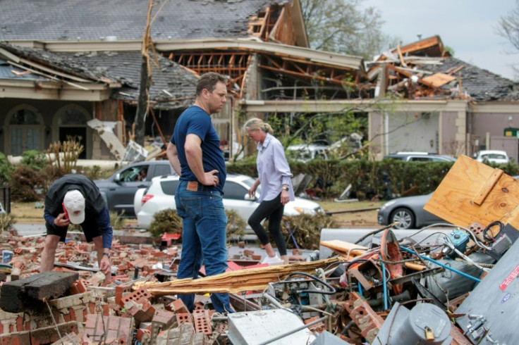
Multiple tornadoes ripped through at least seven states on March 31. One of the areas particularly affected by the weather events was Wynne in Arkansas, where many houses were reportedly crushed or had their roofs ripped off.
Mayor Jennifer Hobbs told CNN the city was "basically cut in half by damage from east to west."
NASA Earth Observatory shared an image of the devastation in Wynne, putting into perspective how the weather event essentially "cut" the area in half. Captured by the Operational Land Imager-2 (OLI-2) on Landsat 9, the image shows the clear "path of damage" of a tornado crossing right through Wynne.
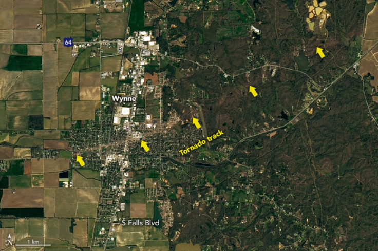
The image was taken on April 1, a day after the tornado hit the city.
In another satellite image, shared by the United States Geological Survey Earth Resources Observation and Science Center (USGS EROS), one can see a close-up view of the tornado's path through the city. It was also captured by Landsat 9 satellite.
The gray stripe shows the tornado's path that cuts across the city. It's rather dangerously close to Wynne High School, which reportedly sustained substantial damages.
An F3 tornado ripped through the community of Wynne, Arkansas, on March 31 and was captured by the @USGSLandsat 9 satellite the next day. Healthy vegetation appears red in this satellite image. The tornado’s path is apparent by the grey stripe that leads to the local high school. pic.twitter.com/MZfl0kqEQe
— USGS EROS (@USGS_EROS) April 3, 2023
The tornadoes caused the deaths of at least 32 people as of Monday, reported AP News. In Arkansas, five people reportedly died, and Gov. Sarah Huckabee Sanders already declared a state of emergency. More than 9,400 residents are still without power in the state as of this writing, according to PowerOutage.us.
It appears Arkansas still isn't out of the woods. A severe weather update from National Weather Service (NWS) in Little Rock said "strong to severe storms" are expected from Tuesday evening to Wednesday morning.
"All hazards will be possible; have a plan in place for Tuesday evening into Wednesday morning to get weather alerts!" it noted.
Severe Weather Update: Tuesday evening thru Wednesday morning expect strong to severe storms to impact the Natural State. Specifics outlined below. All hazards will be possible; have a plan in place for Tuesday evening into Wednesday morning to get weather alerts! #ARwx pic.twitter.com/YW10elJlAL
— NWS Little Rock (@NWSLittleRock) April 3, 2023
The agency warned residents to look out for weather events such as tornadoes, severe wind and severe hail.
An update from the NWS Storm Prediction Center shows a wider-scale warning that includes Arkansas' neighboring states.
"The threat for severe weather, including tornadoes, is expected to increase through the late evening & overnight hours," it noted. "Be sure to have multiple ways to receive warnings."
Portions of #OK, #AR, & #MO have been upgraded to a Moderate (4/5) risk for severe weather tomorrow/Tuesday. The threat for severe weather, including tornadoes, is expected to increase through the late evening & overnight hours. Be sure to have multiple ways to receive warnings. pic.twitter.com/xwrL8W6l1v
— NWS Storm Prediction Center (@NWSSPC) April 3, 2023
It would be best for people in thee areas to keep track of forecasts so they can be well-prepared for these events.
© Copyright IBTimes 2026. All rights reserved.
- MOST READ