

Hurricane Dorian 2019: NWS Corrects Trump, Alabama Won't Be Hit By Hurricane

President Donald Trump decided to play amateur weatherman on Sunday, tweeting Hurricane Dorian -- now a Category 5 monster ravaging northeast Bahamas for the next 24 hours -- will also slam into "South Carolina, North Carolina, Georgia, and Alabama," adding these places "will most likely be hit (much) harder than anticipated."
The president posted, “In addition to Florida - South Carolina, North Carolina, Georgia, and Alabama, will most likely be hit (much) harder than anticipated. Looking like one of the largest hurricanes ever. Already category 5. BE CAREFUL! GOD BLESS EVERYONE!”
Praiseworthy from Trump but dead wrong on one count. There is no way Dorian will hit Alabama and the National Weather Service Birmingham (NWS Birmingham) was so alarmed by Trump’s fake news it was forced to swiftly tweet a rebuttal of its own only one hour later.
“Alabama will NOT see any impacts from #Dorian. We repeat, no impacts from Hurricane #Dorian will be felt across Alabama. The system will remain too far east. #alwx,” tweeted NWS Birmingham.
Alabama will NOT see any impacts from #Dorian. We repeat, no impacts from Hurricane #Dorian will be felt across Alabama. The system will remain too far east. #alwx
— NWS Birmingham (@NWSBirmingham) September 1, 2019
The latest National Hurricane Center (NHC) advisory on Dorian has it weakening into a Category 4 by Tuesday as it tears through Florida’s east coast. It is expected to affect Georgia and the South Carolina later this week.
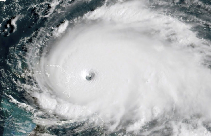
Dorian made landfall in the northwestern Bahamas on Sunday. Its maximum sustained wind speeds of 298 km/h (185 mph) as of Sunday afternoon tore off roofs in The Bahamas and toppled power lines as hundreds of Bahamanians huddled for safety in shelters, schools and churches.
Dorian is officially the strongest hurricane on record in this area. It has tied the record for the most powerful Atlantic hurricane ever to come ashore in the Bahamas. It shares this notoriety with the Labor Day hurricane of 1935, which doesn’t have a name because storms at this time weren’t named.
NHC has issued storm warnings for several areas along Florida’s east coast. It also said rainfall will produce flash floods in the coastal Carolinas and Georgia.
It’s now likely Dorian might spare the U.S. coast a direct hit due to the effects of the Gulf Stream, the warm and swift Atlantic Ocean current originating in the Gulf of Mexico and stretching to the tip of Florida.
The Gulf Stream follows the eastern coastlines of the U.S. Because of the Gulf Stream’s powerful pull, Dorian will move close to Florida's east coast late Monday but won’t likely make landfall. Dorian is expected to affect the South Carolina coast Wednesday or Thursday.
States of emergency are in effect for all of Florida, North Carolina and South Carolina. Twelve counties in Georgia are also in a state of emergency.
Mandatory evacuations are underway in some parts of Florida. Evacuations in coastal South Carolina will begin Monday.
© Copyright IBTimes 2025. All rights reserved.
- MOST POPULAR IN National


