

Extreme Weather 2020: Warnings Issued Along The US East Coast As Isaias Continues North
KEY POINTS
- Storm’s center could come dangerously close to New York City later in the week
- Hurricane watches were issued in areas of South Carolina and North Carolina as Isaias is forecast to regain strength before making landfall
- Flash and urban flood warnings are in effect around the U.S. mid-Atlantic region, with some areas projected to receive up to 8 to 10 inches of rainfall from Isaias
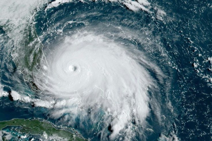
After a weekend pounding the Bahamas and Florida’s east coast, Tropical Storm Isaias is set to continue moving northward along the greater U.S. east coast Monday while regaining strength it lost making landfall on the island chain.
“Isaias is forecast to regain hurricane strength before it reaches the coast of northeastern South Carolina and North Carolina, and hurricane conditions are expected in the Hurricane Warning by this evening,” the National Hurricane Center said. “Preparations should be rushed to completion.”
The name of the storm, pronounced ees-ah-EE-ahs, is a common name of Spanish and Portuguese origin. National Oceanic and Atmospheric Administration public affairs officer Dennis Feltgen told CNN the name was added in 2009 as the replacement for Ike following Hurricane Ike in 2008.
As of Monday, Tropical Storm Isaias had sustained winds averaging 70 mph and was moving north at 9 mph. Tropical storm warnings are in effect up to Rhode Island, and tropical storm watches have been issued as far north as Maine. Hurricane watches were also issued in areas of South Carolina and North Carolina for later on Monday, where Isaias is projected to make landfall after potentially growing back to a category 1 hurricane.
Flood warnings are also in effect for various parts of the U.S. mid-Atlantic region, which is forecast to get hammered by rainfall on Monday and Tuesday. Rainfall is forecast to average 2 to 4 inches, though some areas could receive up to 8 to 10 inches of rain and cause flash and urban flooding.
The heart of Isaias is projected to make landfall around southeastern North Carolina on Tuesday as it moves into the northeastern U.S. Meteorologists have warned the storm’s center could come dangerously close to New York City later in the week after Tropical Storm Fay hit the northeastern states in July.
“The last time there have been two named tropical systems pass so close in the same season was in 1985 when Gloria and Henri passed over Long Island, New York,” AccuWeather Meteorologist Brandon Buckingham said. “In 1960, Brenda and Donna passed within 40 miles of New York City.”
© Copyright IBTimes 2025. All rights reserved.
- MOST POPULAR IN National


