

Extreme Weather: Hurricane Douglas Avoids Mainland Hawaii
KEY POINTS
- Hurricane Douglas missed direct contact with the Hawaiian Islands, though some coastal communities reported strong winds and heavy rains from the storm
- Douglas is forecast to continuing weaking as it moves into the open Pacific, dropping to a tropical depression by Thursday
- One meteorologist warned Hawaii continues to "playing with a really fine line," saying 20 or 30 miles south would have made all the difference for the storms' intensity over the weekend
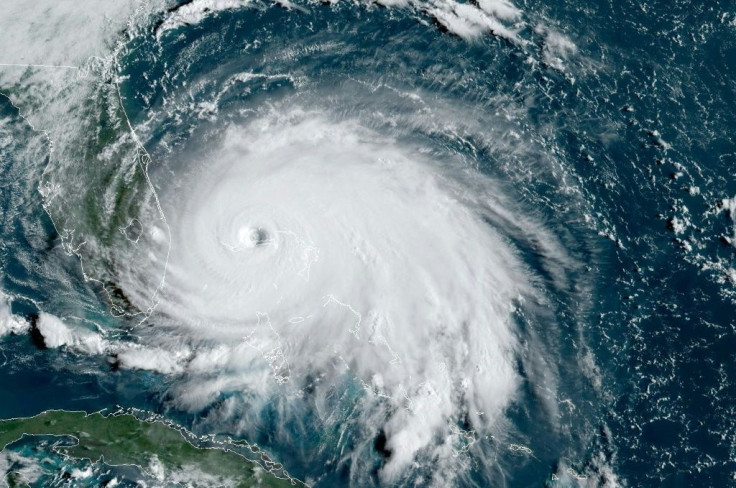
After a weekend looming over the Hawaiian Islands, Hurricane Douglas avoided direct landfall with the island chain. The last hurricane warning for the island of Kauai was lifted on Monday after the heart of the storm was completely past.
“Not only did it not make landfall, it skirted by the islands,” National Weather Service meteorologist Chevy Chevalier told the Associated Press. “The islands are so small; you’re not going to see them get hit that often.”
The National Hurricane Center’s forecast also has the storm beginning to weaken as the week proceeds. It was still at hurricane strength on Monday, winds averaging around 90 mph as it continues to move west into the open Pacific Ocean at 17 mph. It is forecast to weaken to a tropical depression by around 2 a.m. Thursday.
While the heart of the storm missed mainland Hawaii, the islands did not emerge completely unscathed. The island of Maui reported heavy rains and strong gusts for most of Sunday, with some small trees downed on or near roads. Debris was also pushed onto some roads running along beaches on the northern ends of the island thanks to the strong tide during the storm.
Over 300 evacuees have started returning to their homes around the islands of Maui and Oahu after spending the weekend in various emergency shelters.
However, some meteorologists have warned Hawaii continues to skirt dangerous storms one due to hit the islands in force sooner rather than later.
“We were really playing with a really fine line, a razor-thin line between what we’ve experienced today compared to what we could have experienced,” National Weather Service meteorologist Eric Lau said. He added that 20 or 30 miles proved to be the difference and if Douglas had been farther south, Hawaii would have been hit much harder.
© Copyright IBTimes 2025. All rights reserved.
- MOST POPULAR IN National


