

Hurricane Laura Pushes Into Gulf Of Mexico, May Reach Category 3 Strength By The Weekend
KEY POINTS
- Widespread damage and multiple deaths were reported around the Caribbean after Tropical Storm Laura hit
- The National Hurricane Center upgraded Laura to a category 1 hurricane as it moved into the Gulf of Mexico
- Meteorologists fear the storm will grow rapidly, hitting category 3 strength before making landfall
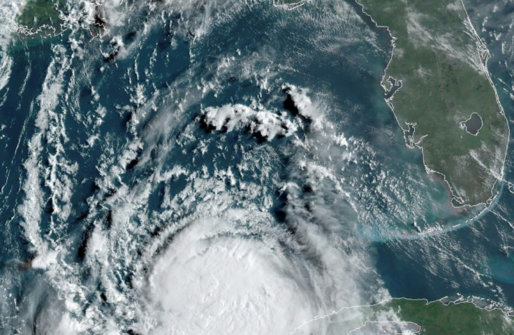
The National Hurricane Center upgraded Laura to a category 1 hurricane as the storm continued its march into the Gulf of Mexico.
As of Tuesday, Hurricane Laura was moving west-northwest at 17 mph with sustained winds averaging 75 mph.
Communities along the Gulf of Mexico got a preview of what is in store from Hurricane Laura after the front hammered the Caribbean over the weekend, killing at least 11 people. Mudslides, flooding, and widespread power outages occurred across Haiti, the Dominican Republican, and Puerto Rico by Monday.
Laura’s current projected path has the heart of the storm making landfall around along Louisiana’s border with Texas around 8 p.m. Wednesday. The strongest storm zone is forecast for eastern Texas and southwestern Louisiana, but severe weather is expected all along Texas’ east coast and most of Mississippi.
“There is a risk of life-threatening storm surge from San Luis Pass, Texas, to Ocean Springs, Mississippi, within the next 48 hours, and a storm surge watch is in effect for these areas outside of the southeast Louisiana Hurricane and Storm Damage Risk Reduction System,” the NHC said. “Residents in these areas should follow any advice given by local officials.”
One of the biggest concerns meteorologists tracking Laura have is its strength before it makes landfall. It is currently sitting in the open Gulf of Mexico and conditions are favorable with mostly warm waters and low wind resistance. The weakening Tropical Storm Marco may provide some resistance, but not enough to weaken Laura significantly.
“Laura will briefly track over the shallow wake of cooler water left in the Gulf from Marco; this might slow Laura's intensification process but only briefly,” AccuWeather hurricane expert Dan Kottlowski said. “Then, Laura will be over very warm water and in a low wind shear environment, which will favor strengthening.”
Under current conditions, Laura is forecast to strengthen to a category 3 hurricane by Thursday with winds averaging 115 mph. This would bring with it an increased tornado threat for much of the Gulf Coast and Midwest going into the weekend, along with worsening floods along rivers and in urban areas.
“The threat of widespread flash and urban flooding, along with small streams overflowing their banks, will be increasing Wednesday night into Thursday from far eastern Texas, across Louisiana, and Arkansas,” the NHC said. “This will also lead to minor-to-isolated moderate river flooding. The heavy rainfall threat will spread northeastward into the middle Mississippi, lower Ohio, and Tennessee valleys Friday and Saturday.”
© Copyright IBTimes 2025. All rights reserved.
- MOST POPULAR IN National


