

Storm Warnings: San Francisco Bay Area Braces For Strong Atmospheric River

KEY POINTS
- Impacts of the atmospheric rain will be felt Wednesday morning through Thursday
- Areas face the risk of flooding, mudslides and destruction caused by severe wind
- Residents were warned against using the roadways until the storm is over
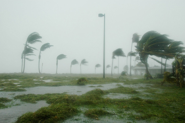
Officials have warned Californians in the San Francisco Bay Area to gear up for a massive storm that could have severely dangerous, possibly catastrophic, impacts.
After the extreme weather over the weekend in California, residents of the SF Bay Area do not have respite yet as a stronger storm will take effect Wednesday. Another atmospheric river with heavy downpours will move across the area and is expected to cause destruction.
The first wave of rainfall is expected to arrive in the area Wednesday morning. The second round of rain with flood-triggering a downpour is expected Wednesday between 2 p.m. to 9 p.m., according to ABC7 Meteorologist Drew Tuma.
The effects of the storm will be felt till Thursday.
A flood watch has been issued by NWS from 4 a.m. Wednesday to 4 p.m. Thursday, CBS News reported.
Major wind and rain impacts are EXPECTED tomorrow into Thursday. Prepare now for flooding, downed trees, and power outages. NEVER drive through flooded roadways! Remember turn around, don't drown. Stay safe everyone! #cawx pic.twitter.com/8agOIHccoJ
— NWS Bay Area 🌉 (@NWSBayArea) January 3, 2023
Officials have also warned residents of the possibility of massive destruction.
"To put it simply, this will likely be one of the most impactful systems on a widespread scale that this meteorologist has seen in a long while," the Bay Area office of the National Weather Service said in a statement.
"The impacts will include widespread flooding, roads washing out, hillside collapsing, trees down (potentially full groves), widespread power outages, immediate disruption to commerce, and the worst of all, likely loss of human life. This is truly a brutal system that we are looking at and needs to be taken seriously," the statement continued.
Meteorologist Kyla Grogan said on KRON4 drivers should avoid using roads Wednesday.
"The heaviest rain is set to fall early Wednesday morning, the result of another atmospheric river that is tapping into a very rich plume of moisture extending far out into the Pacific Ocean," Grogan was quoted saying. "Rain totals with this storm are expected to be similar to our New Year's weekend storm."
Around 1.5 to 3 inches of rainfall is expected in urban areas while 3 to 6 inches of rainfall can be expected in the mountain ranges.
Along with flooding, atmospheric rain also poses the risk of mudslides.
"There is particular concern for those living in landslide-prone areas, burn scar areas, and those living close to rivers ...," Grogan added. "The important message right now is for people to make any preparations they need to on Tuesday ahead of this next storm system."
For residents living in areas that have only one road, the NWS advised them to keep extra supplies in case mudslides, fallen trees or floods block the roadways.
The incoming atmospheric rain is also expected to trigger stronger gusts of wind.
"This is going to be a lot windier than the previous storm. Wind damage could be a really big issue, especially late Tuesday night into Wednesday morning. And heavy, heavy rain," KRON4 Chief Meteorologist Lawrence Karnow noted.
© Copyright IBTimes 2026. All rights reserved.
- MOST READ


