

US Weather: Flood Warnings Up In 7 States; Extensive Flooding Possible In Midwest

KEY POINTS
- Rapid runoffs are possible in parts of western Ohio Valley and middle/lower Mississippi Valley
- Up to four inches of rain is expected in portions of Indiana
- Two rivers in Indiana may reach flood stage Friday
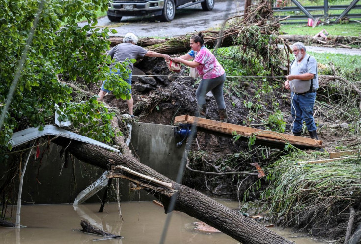
Multiple flood-related advisories have been issued as weather forecasters warn of significant flooding across the Midwest over the weekend. Heavy rain and strong winds are expected as another storm system approaches the United States from the Southern Plains.
"Flooding is definitely going to be a very big concern going forward, with some very large rain totals," the Weather Channel (TWC) meteorologist Danielle Banks said Wednesday. Banks added that rain will continue "past Friday evening."
"Multi-inch rainfall totals are possible from the Ohio Valley into the mid-Mississippi Valley and mid-South Thursday and Friday," which could produce flash flooding in affected areas, TWC reported.
"The associated heavy rain in parts of the western Ohio Valley and middle/lower Mississippi Valley will create localized flash flooding, affecting areas that experience rapid runoff with heavy rain," the Weather Prediction Center (WPC) said in a report Wednesday. A runoff happens when the ground can no longer absorb more water due to excessive precipitation.
The National Weather Service (NWS) has issued flood watches, effective through Saturday, amid concerns that the weather may turn severe, particularly in north-central Indiana, CBS-affiliated WTTV reported.
Rainfall totals are expected to reach up to four inches in Indiana through Saturday. The highest rain accumulations are expected in southern and south-central Indiana.
Multiple rounds of heavy rainfall expected Thursday through early Saturday across Indiana. Total rainfall amounts of 2 to 4+ inches are likely through Saturday with the highest totals across Southern and South Central Indiana. Flood Watch 8 PM Thu thru 8 AM Sat. pic.twitter.com/HcQJCQnX3m
— NWS Indianapolis (@NWSIndianapolis) March 22, 2023
In Oklahoma, parts of Tulsa are expected to get up to four inches of rain through Saturday. The highest probability of severe storms is expected across south-central Oklahoma, the NWS said.
Very heavy rainfall expected from Oklahoma into the Ohio River Valley over the next three days will mean the potential for flash flooding for many. Check https://t.co/VyWINDk3xP for the latest, local details – and remember:
— National Weather Service (@NWS) March 22, 2023
Turn Around, Don't Drown. pic.twitter.com/zNmdaOCJgY
Some strong to severe thunderstorms are expected tomorrow and into tomorrow night. Highest probabilities of severe storms appear to be across south-central Oklahoma, along the Red River, and over western north Texas.#okwx #texomawx pic.twitter.com/0NvDhA7Zd7
— NWS Norman (@NWSNorman) March 23, 2023
In Missouri, flooding is expected in "many" creeks, streams and rivers across the state. Weather officials are expecting flooding to occur in the Black, Big, Meramec, Kaskaskia and Bourbeuse Rivers.
Heavy rain is expected Thursday night into Friday, with some areas receiving in excess of 3 inches. This will lead to flooding on many creeks, streams, and rivers in the affected areas. Flooding may last into the weekend. pic.twitter.com/y4TjokghOH
— NWS St. Louis (@NWSStLouis) March 23, 2023
Forecasters in Ohio warned of up to three inches of rain in Wilmington, Cincinnati, Butler, Dayton, Richmond, Osgood, Brookville, Carrollton and Sardinia.
Heavy rain is forecast Thursday night into Saturday, thanks to a slow moving boundary meandering across the Ohio Valley. Pay attention to any Flood Warnings or Advisories that may be issued for your location. pic.twitter.com/zftXas1Efo
— NWS Wilmington OH (@NWSILN) March 23, 2023
Forecasters are expecting some thunderstorms in Kentucky Friday, which could result in minor flooding and some flash flooding.
A wet and unsettled pattern is likely to develop late this week. #kywx #inwx pic.twitter.com/OPA71Qlwpe
— NWS Louisville (@NWSLouisville) March 22, 2023
In Tennessee, the main threat is the possibility of straight-line winds and heavy rainfall hitting the state late Friday.
We're keeping an eye on Friday as there is a chance for strong to severe thunderstorms during the evening and overnight hours. Right now, the main threat looks to be straight-line winds and heavy rainfall. Stay weather-aware! #TNwx pic.twitter.com/od5jJpykyW
— NWS Nashville (@NWSNashville) March 22, 2023
Straight-line winds, like tornadoes, come from thunderstorms, but they do not have a rotating movement, unlike tornadoes. The NWS noted that "most years there are far more damage reports from thunderstorm straight line winds than from tornadoes."
Indiana flood alerts
Flood watch effective from Thursday evening through late Friday night:
- Vanderburgh, Posey, Gibson, Warrick, Spencer and Pike
Flood watch effective from Thursday evening through Saturday morning:
- Bartholomew, Decatur, Hancock, Hendricks, Johnson, Marion, Morgan, Rush and Shelby in central Indiana
- Henry in east central Indiana
- Jennings in southeast Indiana
- Brown, Jackson, Monroe and Lawrence in south-central Indiana
- Daviess, Martin, Greene, Knox and Sullivan in southwest Indiana
- Vigo, Clay, Putnam and Owen in west-central Indiana
Flood watch effective from Thursday evening through Saturday afternoon:
- Dearborn, Franklin and Fayette
- Floyd, Orange Clark, Washington, Scott, Perry, Harrison, Crawford, Floyd, Dubois and Jefferson
Oklahoma flood alerts
Flood watch effective from Thursday afternoon through Friday evening:
- Adair, Cherokee, Craig, Wagoner, Tulsa, Sequoyah, Rogers, Ottawa, Creek, Delaware, Muskogee, Okfuskee, Mayes, Okmulgee and McIntosh
Flood watch effective from Thursday afternoon through Friday morning:
- Cleveland, Pottawatomie, Lincoln, Oklahoma and Seminole
Missouri flood alerts
Flood watch effective from Friday morning through 5 p.m. Saturday:
- Roubidoux Creek near Waynesville (flood stage of 7 feet may be reached Friday morning)
Flood watch effective from Friday evening through 5:30 p.m. Sunday:
- Gasconade River at Hazelgreen (flood stage of 21 feet may be reached late Friday evening)
Flood watch effective from Thursday afternoon through late Friday night:
- Barry, Christian, Dade, Dent, Douglas, Greene, Oregon, McDonald, Newton, Lawrence, Jasper, Ozark, Phelps, Shannon, Stone, Taney, Texas, Webster and Wright
Flood watch effective from Thursday evening through late Friday night:
- Bollinger, Cape Girardeau, Wayne, Stoddard, Ripley, New Madrid, Carter and Scott
- Dunklin, Pemiscot, Iron, Reynolds, and Madison
Ohio flood alert
Flood watch effective from Thursday evening through Saturday afternoon:
- Clermont, Preble, Warren, Greene, Hamilton, Clinton, Butler and Montgomery
Illinois flood alerts
Flood warning effective from Friday evening through Thursday, March 30:
- Embarras River at Lawrenceville (at a flood stage of 30 feet, the river may crest at 35.1 feet early Sunday morning)
Flood warnings effective until further notice:
- Little Wabash River below Clay City (at a flood stage of 18 feet, the river may crest at 21.7 feet Saturday evening)
- Illinois River at Beardstown affecting Cass, Schuyler, Morgan and Brown Counties
- Illinois River near Havana affecting Mason and Fulton Counties
- Little Wabash River at Carmi (river may exceed flood stage of 27 feet to 31.9 feet Wednesday morning)
Kentucky flood alerts
Flood watches effective from Thursday evening through 5 p.m. Saturday:
- Boone, Campbell, Gallatin, Bracken, Carroll, Kenton, Grant, Pendleton, Owen and Robertson
- Anderson, Breckinridge, Fayette, Bourbon, Franklin, Bullitt, Hardin, Jefferson, Henry, Harrison, Meade, Nicholas, Nelson, Oldham, Trimble, Woodford and Spencer
Flood watch effective from Thursday evening through late Friday night:
- Crittenden, Livingston, Ballard, Carlisle, Henderson, McCracken, Union, Daviess and McLean
Tennessee weather alert
Hydrologic outlook issued Wednesday night:
- Heavy rain and potential flooding possible from Thursday through Friday night for parts of extreme northwest Tennessee
© Copyright IBTimes 2025. All rights reserved.
- MOST POPULAR IN National


