

Tropical Storm Gordon: New Orleans Expects Heavy Rainfall From 'Brown Ocean' Effect

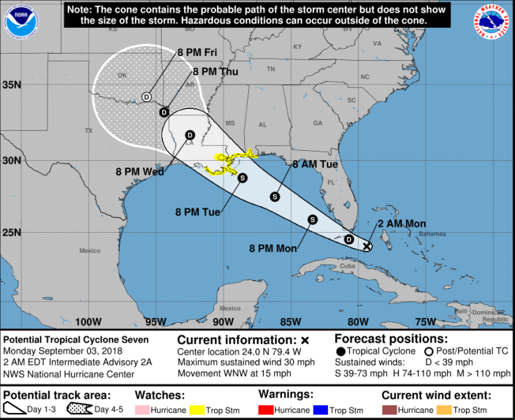
As the National Hurricane Centre (NHC) monitored Tropical Cyclone Seven, located 175 miles east-southeast of Marathon, Florida, on Sunday, the National Weather Service (NWS) issued a storm watch for parts of central Gulf Coast.
“Thunderstorm activity associated with a tropical wave located between north-central Cuba and the central Bahamas is gradually becoming better organized, and upper-level winds are also becoming more favorable,” NHC said Sunday. “A tropical depression is likely to form during the next day or so while the system moves west-northwestward across the northwestern Bahamas, southern Florida, and the Florida Keys.”
NHC is issuing advisories on Potential Tropical Cyclone Seven located near the Central Bahamas and northern Cuba. Tropical Storm Watches have been issued for portions of the central Gulf Coast. Here are Key Messages for this advisory and go to https://t.co/tW4KeGdBFb for info. pic.twitter.com/lgeoyhE8QI
— National Hurricane Center (@NHC_Atlantic) September 2, 2018
"The system is forecast to emerge over the southeastern Gulf of Mexico on Monday afternoon and move toward the north-central Gulf Coast Tuesday night and Wednesday,” it said.
The storm watch extended from the Alabama-Florida border westward to east of Morgan City, Louisiana, including Lake Pontchartrain and Lake Maurepas.
Cyclone Seven was seen moving west to northwest at 15 mph, 11 p.m. EDT on Sunday, NHC said, adding that the tropical depression had an 80 percent chance of becoming Tropical Storm Gordon in the next 48 hours, as it packed maximum sustaining winds of 30 mph.
Central Florida would be experiencing a wet Labor Day on Monday. According to NWS, scattered showers were expected in the region before 8 a.m. EDT, then scattered showers and thunderstorms between 8 a.m. and 11 a.m. EDT.
According to Newsweek, New Orleans area and south Mississippi could get up to five inches or more of rain as the week progressed, even though weather analyzing models predicted "weak tropical storm" to wash over the region. This is due to the “Brown Ocean” phenomenon.
"Our experimental Deep Thunder model (from IBM) is indicating (amongst other models) a weak Tropical Storm to impact the New Orleans + vicinity area later this week," tweeted Michael Ventrice, a meteorological and software engineer at The Weather Company. "Note this model continues to develop this storm over land, which suggests the 'Brown Ocean' phenomena."
The “Brown Ocean” phenomenon occurs when a tropical storm deviates from its conventional pattern of gradually dissipating once it entered land and instead, intensifies on land.
Nevertheless, it was highly unlikely that Storm Gordon would become a hurricane in the coming days, NHC reported. The storm is projected to reach the coast between Alabama and Louisiana on Tuesday night or Wednesday morning and continue on its west-northwesterly track through Wednesday, leaving it little or no time to intensify into a hurricane.
Florida Governor Rick Scott warned locals and tourists to monitor the weather system and be prepared to follow instructions as and when given.
"Right now, according to @NHC Atlantic, the biggest impact to our state will be heavy rain, but in Florida, we know how quickly weather can change," he tweeted. "With the peak of hurricane season upon us, now is the time to get prepared. Make sure that you and your family have a plan in place in case of disaster."
© Copyright IBTimes 2025. All rights reserved.
- MOST POPULAR IN National


