

WATCH: Terrifying Moment Pilot Flies Into Hurricane Irma
A video showing a weather plane flying directly into the eye of Hurricane Irma, a Category 5 storm that made landfall in the islands of the northeast Caribbean early Wednesday, has gone viral. The video was shot Tuesday aboard National Oceanic and Atmospheric Administration flight NOAA42.
The terrifying video shows pilot Nick Underwood's plane shaking as it tries to measure the intensity of the hurricane. The data collected by Underwood will be used to build prediction models for Irma.
"My headset on the plane lets me pipe in some music. It automatically lowers the music volume when someone talks so you still know what's up," Underwood wrote on Twitter describing his experience. "On last night's flight we're approaching the storm at like 4 in the morning and I'm a little sleepy, so I put the workout playlist on. We're flying along and as we enter the eyewall (where bumps tend to be the worst) 'X Gon' Give It To Ya' by DMX comes on and it's PERFECT."
"So you can imagine me in an airplane getting tossed around in a major hurricane and just going HARD to DMX. I loved it," he wrote.
The National Hurricane Center issued a warning about tropical storm Jose, the weather system behind Irma, saying that it could soon become a hurricane.
"Maximum sustained winds have increased to near 60 mph (95 km/h) with higher gusts. Additional strengthening is forecast, and Jose is expected to become a hurricane by tonight," the center wrote.
Video of a flight through the eye of #Irma on #NOAA42. Flights on both the WP-3D Orion and G-IV #NOAA49 continue. Credit Nick Underwood/NOAA pic.twitter.com/9ini4bOnYF
— NOAA Aircraft Operations Center (@NOAA_HurrHunter) September 5, 2017
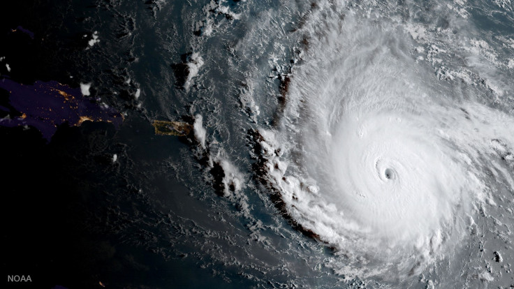
Hurricane Irma, which is churning along a path pointing to Puerto Rico, the Dominican Republic, Haiti, and Cuba, is heading for Florida and is expected to make landfall there Saturday.
Irma could be one of the strongest hurricanes to hit the United States as it is traveling with maximum winds of up to 185 miles per hour.
“Irma is a potentially catastrophic category 5 hurricane and will bring life-threatening wind, storm surge, and rainfall hazards to portions of the northeastern Leeward Islands tonight and tomorrow,” the National Oceanic and Atmospheric Administration (NOAA) said in a statement Tuesday. “These hazards will spread into the Virgin Islands and Puerto Rico tomorrow. Preparations should be rushed to completion before the arrival of tropical-storm force winds tomorrow morning in Virgin Islands and Puerto Rico.”
"The chance of direct impacts from Irma beginning later this week and this weekend from wind, storm surge, and rainfall continues to increase in the Florida Keys and portions of the Florida Peninsula. However, it is too soon to specify the timing and magnitude of these impacts," NOAA wrote.
A public advisory was issued for St Kitts and Nevis, a dual-island nation in the Carribean, asking residents to stay indoors.
“The security forces have advised that the public should be foremost concerned about their safety and well-being and therefore should refrain from being on the streets after 6 p.m. Only essential workers are expected to be outdoors and on the streets. Moreover, we seriously advise, for their own safety and security, that our citizens and residents remain indoors and continue to listen to all official advisories on the hurricane. The official government agencies will indicate when it is safe to venture outdoors after the passage of the hurricane," Prime Minister Timothy Harris said in a statement. “All of our national security agencies have been fully mobilized and are on highest alert.”
© Copyright IBTimes 2025. All rights reserved.
- MOST POPULAR IN National


