

When Does Hurricane Season Start? Atlantic, Pacific Storm Forecasts Predict Many Cyclones
Calling it hurricane season is a bit misleading since it’s more like a hurricane half-year. In the Atlantic it starts every June 1 and runs through the summer and well into the fall, officially ending after November.
Forecasts indicate the next six months might be rough. The Washington Post reported forecasters are predicting an especially active season because conditions such as ocean water temperature are favorable for cyclones.
Read: Satellites Orbit Earth In Mesmerizing Loops To Observe Environment
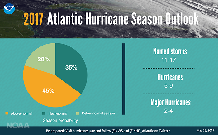
Usually there are 12 named storms, six of which often become hurricanes, with three turning into major events. But the U.S. National Oceanic and Atmospheric Administration is predicting the season will be “above-normal,” with a 70 percent chance of there being 11 to 17 named storms, with five to nine hurricanes in that batch — and two to four major hurricanes within that group.
The prediction numbers account for the tropical storm nicknamed Arlene that already affected the Atlantic in April.
Last year’s hurricane season, by comparison, was fairly active, with 15 named storms, four of which were major hurricanes and three weaker hurricanes, NOAA said. And that was the most activity the region had seen since 2012.
The Pacific might have a bit of an easier go of it, with five to eight tropical cyclones predicted. Although that’s a lower count than the number expected in the Atlantic, it’s still above average as the Pacific typically has only four or five.
Although the forecasts are projecting the number of cyclones likely to form in the Atlantic and the Pacific, they do not predict how many will make landfall since conditions and patterns vary. Hurricanes most often affect tropical areas like Florida and the Gulf of Mexico.
And not all storms are created equal. A Category 1 cyclone has wind speeds of 74 -95 mph. That can cause damage on land but it pales in comparison to a Category 5 storm, which has wind speeds exceeding 157 mph.
Despite the large window of June to November, the majority of storms occur in August, September and October.
The prediction that this hurricane season will be an active one won’t come as a surprise to some as climate scientists project hurricanes will come more often and blow more intensely.
Read: Photos Show Deadly Joplin Tornado’s Destruction
That’s dangerous, not just to people living in the coastal areas where the hurricanes might touch down and to ships at sea, but also to wildlife. Birds can get caught in a hurricane’s crosshairs. Researchers looking specifically at an Atlantic seabird the sooty tern and, after mapping its migrations over the last several decades and comparing that data with the paths of hurricanes, found substantial overlap between the two.
“That means these birds, who are usually very tired from traveling long distances over water without rest, are flying head-on into some of the strongest winds on the planet,” study leader Ryan Huang said in a Duke University statement.
The scientists also found dead birds where it was likely the storms had whirled through. And more storms means more dead sooty terns, along with other species.
© Copyright IBTimes 2026. All rights reserved.
- MOST READ


