

NASA Satellite Image Shows Hurricane Fiona Over Puerto Rico

KEY POINTS
- Storms ravaged Puerto Rico and Japan over the weekend
- NASA and NOAA satellites captured the massive storms
- Both places saw damages and power outages
Hurricane Fiona and Typhoon Nanmadol brought heavy rains and flooding to Puerto Rico and Japan. Satellites have captured images of the massive hurricane and typhoon from space.
NASA Earth Observatory shared a photo of the hurricane as its "image of the day" Tuesday. The natural color image of Hurricane Fiona was taken by the Moderate Resolution Imaging Spectroradiometer (MODIS) instrument aboard NASA's Terra satellite.
In the photo, one can see the massive hurricane just before it made landfall Sunday.
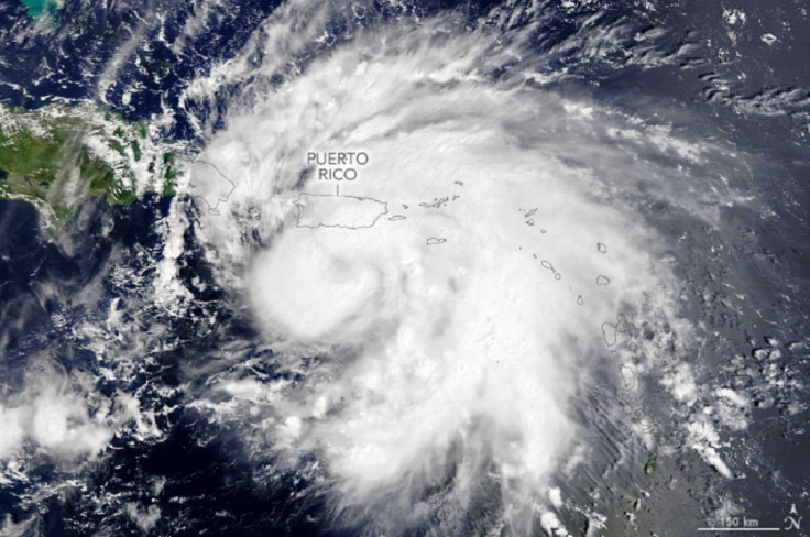
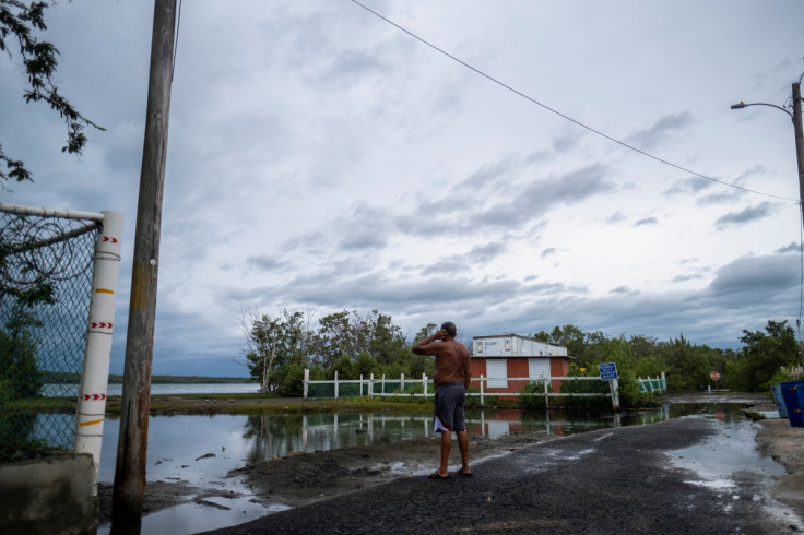
According to the agency, even though Hurricane Fiona is considered a category 1 hurricane, which is the lowest on the five-category Saffir-Simpson Wind Scale, its slow movement gave it a lot of time to cause major damage to Puerto Rico.
By Monday, it was estimated that some 90% of people on the island did not have electricity, PowerOutage.us data showed.
"Restoration is underway after an island-wide blackout caused by hurricane Fiona," the website noted. "Updates, exact numbers, and restoration timelines are not available."
Gov. Pedro Pierluisi told CNN two people were killed because of the hurricane. One of them, a 58-year-old man, reportedly died after being swept away by the La Plata River.
After ravaging Puerto Rico over the weekend, Hurricane Fiona headed over to the Dominican Republic, where it intensified further into a Category 2 storm. It is expected to become a "major hurricane" by Wednesday, CNN reported.
"It was the third Atlantic hurricane of the 2022 season," according to NASA Earth Observatory.
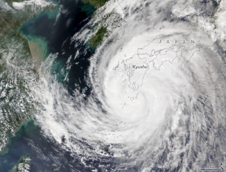
On the other side of the world, another storm was also raging. In a natural-color image captured by the Visible Infrared Imaging Radiometer Suite (VIIRS) instrument on the NOAA-20 satellite Sunday, one can see the massive scale of Typhoon Nanmadol over Japan.
Astronaut Bob Hines also shared several photos of the typhoon.
"It's incredible how something that seems so beautiful from space can be so terrible on Earth...Praying for the safety of those in the path of Typhoon Nanmadol," Hines tweeted.
It’s incredible how something that seems so beautiful from space can be so terrible on Earth…Praying for the safety of those in the path of Typhoon Nanmadol. pic.twitter.com/4xambFgtj6
— Bob “Farmer” Hines (@Astro_FarmerBob) September 17, 2022
Nanmadol made landfall near Kagoshima as a category 2 storm, dumping 300 to 500 millimeters of rain, according to NASA Earth Observatory. It caused landslides, streams and rivers to overflow, and also cut the power supply to hundreds of thousands of people.
Typhoon Nanmadol left two people dead and more than a hundred people injured, reported The Japan Times, dubbing it "one of the most powerful the country has ever seen."
© Copyright IBTimes 2025. All rights reserved.
- MOST POPULAR IN Environment


