Tropical Storm Dorian Update, Path: Storm To Hit Barbados By Tuesday, Could Reach Hurricane Strength
Puerto Rico looks to be first in line to get hit by Tropical Storm Dorian in what appears to be a week of storms for the Caribbean and Florida gulf.
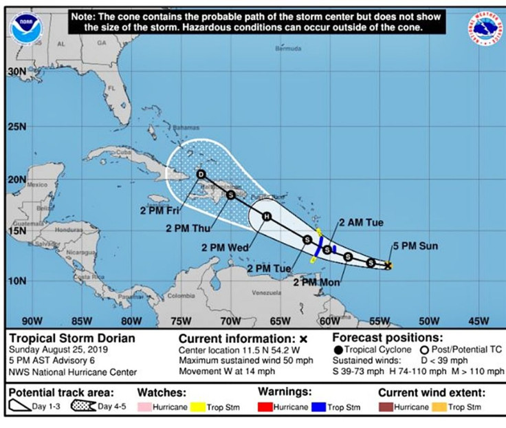
Since forming Saturday, the weather front that started as a tropical depression quickly strengthened to a tropical storm by Monday morning. It has gained strength and has continued moving northwest towards land with the Caribbean first up to get hit by the storm.
As of Monday, the storm’s center was located 205 miles southeast of Barbados and moving at 14 mph westward. Barbados, St. Lucia, and the rest of the island chain south of Puerto Rico have already had tropical storm warnings issued as the residents prepare themselves for Dorian’s arrival. Current projections have the storm hitting the islands sometime Tuesday.
Based on those projections, the islands won’t be enough to slow down the storm significantly, either. The U.S. National Hurricane Center believes that Dorian could reach hurricane strength by Tuesday as well; making the storms that hit the islands that day worse.
The storm is expected to continue picking up strength through Wednesday as it barrels towards Puerto Rico. It would be next up to get hit, along with the Dominican Republic and Haiti, sometime between Wednesday and Thursday. This is also the period where Dorian is expected to be at its strongest, meaning the trio could be facing the worst of the storm.
By Friday and Saturday, Dorian is projected to continue working its way northwest but is expected to slow down significantly by then. Winds are predicted to fall below 40 mph by the time it hits Cuba and forecasters are waiting to see what Southern Florida could have to deal with in the wake of the Caribbean being hit.
© Copyright IBTimes 2026. All rights reserved.
- MOST READ