

Utah’s Great Salt Lake Is Shrinking Drastically, NASA Images Reveal


Utah’s Great Salt Lake is the largest water body in the United States after the Great Lakes. However, five years of drought in the American West has caused the water body to shrink drastically, as is evident from images of the lake released by NASA on Thursday.
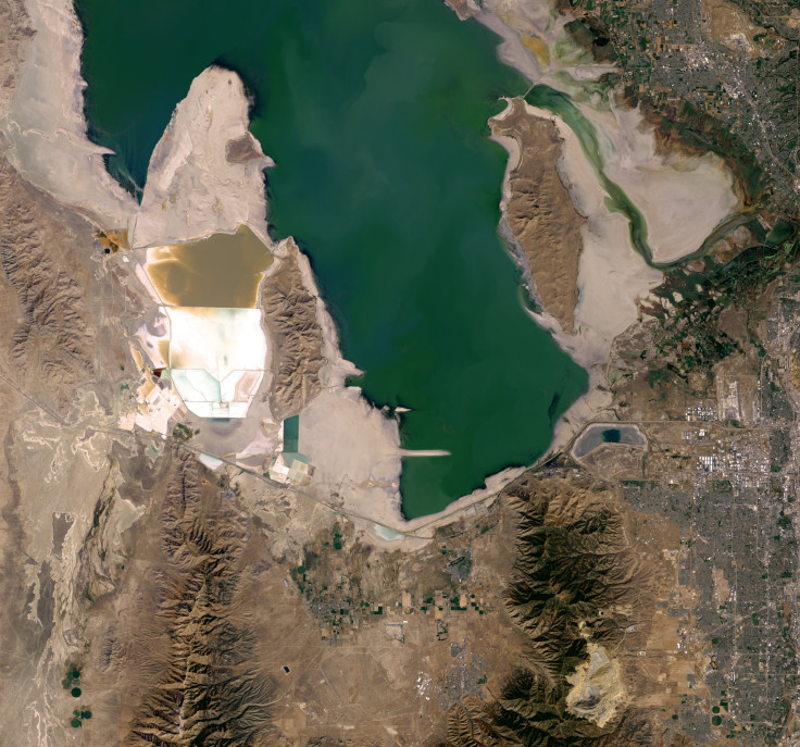
The two Landsat satellite images — which were captured in September 2011 and September 2016, respectively — reveal that the water level in the lake’s Farmington Bay has plummeted to such an extent that three-quarters of the lake bed is now exposed.
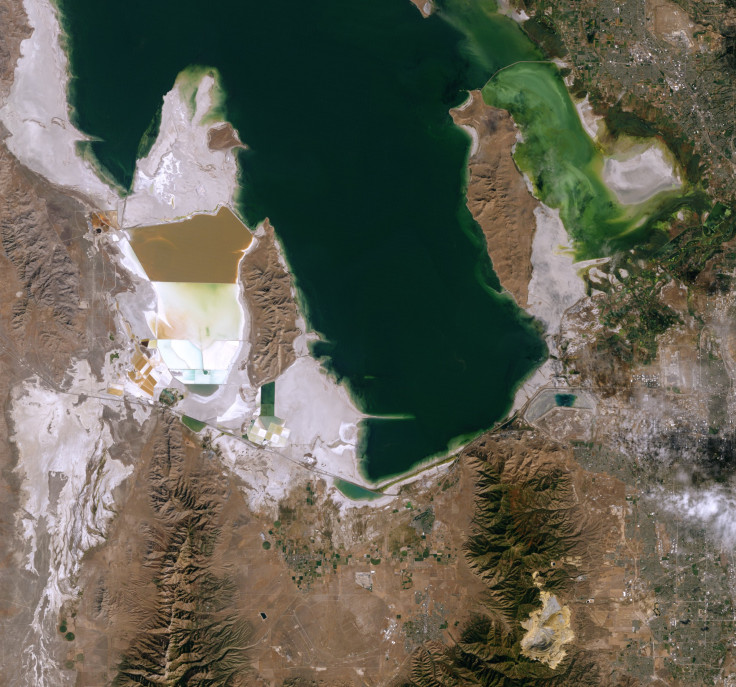
“Farmington Bay has been nearly desiccated as the result of the combined effects of drought and water withdrawals from the rivers feeding the lake,” Wayne Wurtsbaugh from the Utah State University said in a statement accompanying the images. “Farmington Bay is an immensely important feeding area for migratory shorebirds and waterfowl. Even at the low level we have now, it is still important, but the greatly reduced size has diminished its value.”
The Great Salt Lake, which is a terminal basin, is three to five times saltier than the ocean. This not only makes it a natural wonder, but also a rich ecosystem where creatures such as brine shrimps — a key food source for over 250 migratory birds — thrive.
In a recent white paper, Wurtsbaugh and his colleagues state that over the past 150 years, humans have been taking more water out of the Great Salt Lake than what has been flowing into it. This, coupled with the fact that there has been no significant long-term change in precipitation, has caused its net river inflow to drop by 39 percent, which, in turn, has caused the volume of water in the lake to plummet by 48 percent since 1847.
Last month, the water level in the lake fell to 4,191.2 feet — the lowest in recorded history. Moreover, while water was once spread across an area of over 1,600 square miles, it now occupies just 1,050 square miles.
“Any future development of water will cause the lake to drop more. For example, the Utah Division of Water Resources estimates that water consumption associated with the proposed Bear River Development Project would decrease the level of Great Salt Lake approximately 8.5 inches. This would expose about another 30 square miles of lake bed,” Wurtsbaugh and his colleagues wrote in the paper. “The logic is straightforward: if less water is delivered to the lake, the lake level must drop. This is an inevitable consequence of ever increasing water consumption.”
© Copyright IBTimes 2025. All rights reserved.
- MOST POPULAR IN National


