

Dixie Fire: Smoke From California's Second-Largest Wildfire As Seen From Space [Images]

KEY POINTS
- California's Dixie Fire started in mid-July
- Images taken from space show thick smoke coming from the historic fire
- To date, the fire has burned 489,287 acres of land
The Dixie Fire has made history by becoming the second-largest wildfire in California. To show how big the fire is and the massive plumes of smoke it has been producing, NASA Earth Observatory has shared images from space.
California's Dixie Fire started in mid-July and has so far overtaken Oregon's Bootleg Fire as the largest fire in the U.S. this year. In images shared by the observatory, one can see the impact of the historic fire covering the landscape in thick smoke.
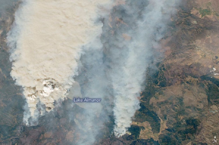
In one of the images, one can see the massive plumes rising from the wildfire on Aug. 4. A member of Expedition 65 took the said image using a Nikon D5 digital camera while aboard the International Space Station (ISS).
In another image from the same day, this time by the Enhanced Thematic Mapper Plus (ETM+) on the Landsat 7 satellite, one can also see the smoke coming from the fires. However, this one combines natural color with shortwave-infrared light to highlight the active fires.
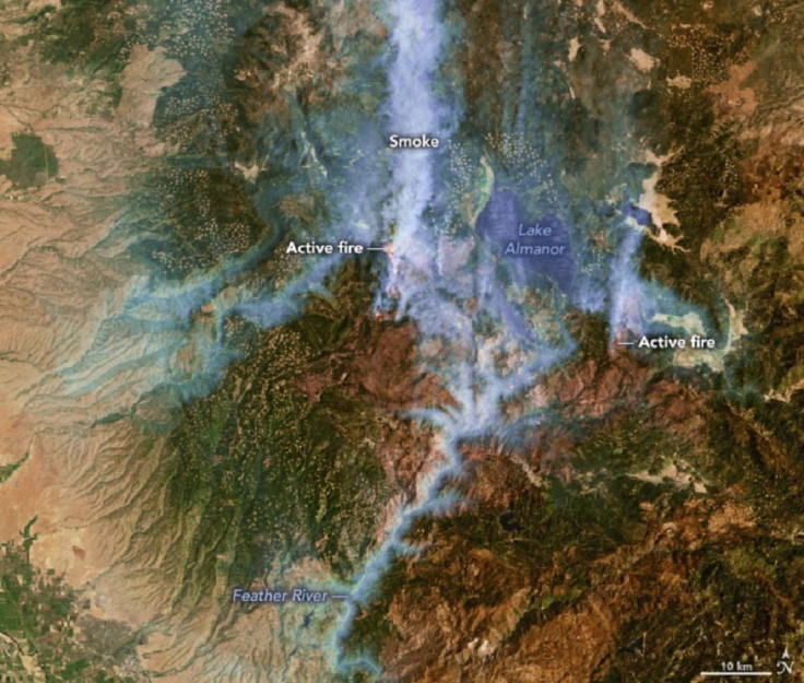
"In this view, the hottest and most active parts of the fire are orange-yellow," NASA Earth Observatory explained.
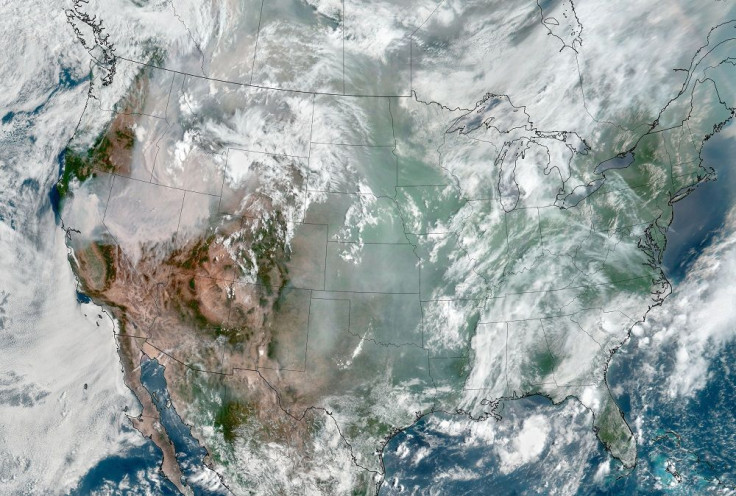
A third image shared by the agency shows a massive plume of smoke days later on Aug. 6. Here, one can see the smoke coming from the Dixie Fire as well as "dozens of others" that are burning across the U.S. The image, which shows a large chunk of the land covered in the thick plumes, was taken by the GOES-17 satellite.
As mentioned, the Dixie Fire is now the second-largest fire in California history. As of Aug. 8 evening, the fire has been active for 25 days. It has burned 489,287 acres of land and is only 21% contained.
The cause of the fire remains "under investigation," according to CAL Fire.
Evacuation orders have been issued in several areas, and authorities continue to urge people to make sure their families are ready to evacuate.
The #DixieFire is now the 2nd largest fire in California’s history. As firefighters continue their fight against 11 major wildfires/complexes across the state, please take the time to ensure you and your family are #EvacuationReady by visiting https://t.co/gIN3kS6vHF. pic.twitter.com/92PFACuLYS
— CAL FIRE (@CAL_FIRE) August 8, 2021
So far, no deaths or public injuries have been reported. However, there are still four people that are still unaccounted for, Plumas County said Sunday.
This Sunday, 8,574 firefighters continue to fight 11 major wildfires/complexes in California. Do your part ensure you are prepared for a wildfire by visiting https://t.co/gIN3kS6vHF. pic.twitter.com/MAgwFfMlmd
— CAL FIRE (@CAL_FIRE) August 8, 2021
"The length of fire season is estimated to have increased by 75 days across the Sierras and seems to correspond with an increase in the extent of forest fires across the state," CAL Fire said in its 2021 fire season outlook. "NIFC predicts portions of the Coast Ranges, Sierra, and Cascades in California increasing to above normal fire danger in June and July and continuing through September."
© Copyright IBTimes 2025. All rights reserved.
- MOST POPULAR IN National


