

Satellite Captures Inundated California After Onslaught Of Atmospheric Rivers [Photo]

KEY POINTS
- California saw two successive atmospheric rivers within a span of days
- Satellite images a year apart show the impact of the weather events
- The rains evidently helped ease the drought conditions in the state
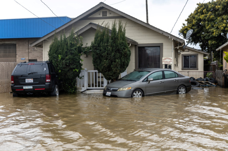
California was hit by two atmospheric rivers this March and now a satellite has captured a view of the inundated Sacramento and San Francisco Bay areas after the onslaught of these weather events.
Eleven atmospheric rivers have reportedly affected California this year, but two successive events in March left the state flooded and more than 400,000 residents without power. The first one for March dropped five to 13 inches of rain from March 10 to 11, noted NASA Earth Observatory. The other one happened just days later on March 14, which even ended up halting flights at the San Francisco airport.
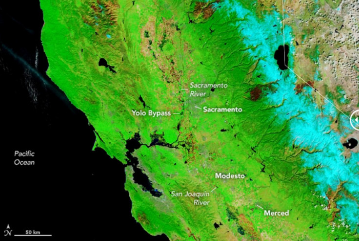
In the image shared by NASA Earth Observatory, one can see the Sacramento and San Francisco Bay areas inundated by rain, as captured by the Moderate Resolution Imaging Spectroradiometer (MODIS) instrument on the Terra satellite on March 16, when the clouds cleared up.
Two successive atmospheric rivers hit California this month, bringing rain, snow, and strong winds. On March 16, NASA’s Terra satellite acquired this false-color image where snow is light blue, water dark blue, and vegetation green.
— NASA Earth (@NASAEarth) March 18, 2023
🔗 https://t.co/e6mrAPm3e5 pic.twitter.com/Nn2dyg06uw
The light blue areas are snow while the dark blue areas are water. The (above) image shows just how flooded the areas had become, rather notably along the Sacramento and San Joaquin rivers.
For comparison, the agency shared an image of the same area from the same date a year prior in 2022. Together, one can truly see the stark difference between the two areas a year apart.
Atmospheric rivers are "vast airborne corridors of water vapor" that flow from the Tropics to the higher latitudes, NASA explained. Although this can bring all-important rain to parched lands, if they come at extreme levels, they can actually be destructive. In fact, NASA Earth Observatory called them "some of the most hazardous storm types in the middle latitudes."
Such was the recent case in parts of California. Red Bliss at Sacramento River, for instance, was flooded to 259 feet in elevation — just a foot short of 1997's record high of 260 feet, according to the National Weather Service (NWS) Sacramento.
The "abnormally wet winter" has reportedly helped ease the drought through the western U.S., said the National Oceanic and Atmospheric Administration (NOAA). This includes California, which has been experiencing "exceptional and extreme drought." And these improvements to drought conditions are expected to persist in the Spring.
Other areas, however, are expected to continue experiencing "extreme to exceptional" droughts throughout the Spring.
"Climate change is driving both wet and dry extremes, as illustrated by NOAA's observations and data that inform this seasonal outlook," NOAA Administrator Rick Spinrad said.
But in the case of California, it appears that residents would need to brace themselves for even more rain in the coming week.
A trough will bring widespread rain and mountain snow across the Western U.S. into Monday with the heaviest snow in the Sierras and central Rockies. A significant storm will push onto the West Coast Tuesday with another round of heavy rain, heavy mountain snow, and high winds. pic.twitter.com/EFqOIsAtqZ
— National Weather Service (@NWS) March 20, 2023
Stay updated on weather forecasts to be prepared for such events.
© Copyright IBTimes 2026. All rights reserved.
- MOST READ


