

Tropical Storm Chris Forecast, Threat Level, Map, Wind Speeds And More
Tropical Storm Chris has formed above the north Atlantic Ocean, coming as an early third tropical storm of the 2012 hurricane season and alarming boaters and others who spend time at sea in that general region.
But it seems to be benign enough, and far enough from shore, that it will most likely not make landfall and will instead peter out at sea.
Either way, the National Weather Service's National Hurricane Service -- a department of the National Oceanic and Atmospheric Administration -- is tracking it and providing forecasts as it continues to develop and move through the area.
Though it is a rather innocuous storm, it does have the privilege of being the third official tropical storm of the 2012 hurricane season, which is turning out to be a very early one, according to Dr. Rick Knabb of the National Hurricane Service.
Only twice before on record (1887,1959) has 3rd Atlantic storm of year formed earlier than this date, he tweeted Tuesday at 88 p.m.
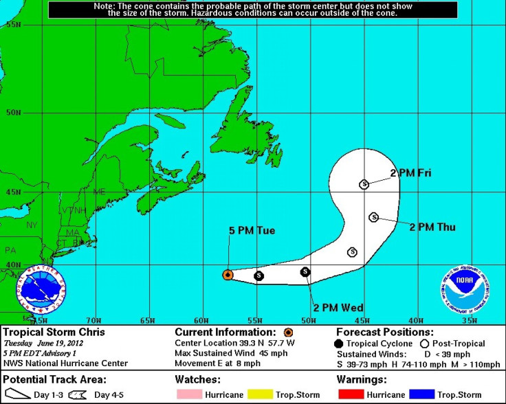
As of 5 p.m. Tuesday, the storm was a tropical cyclone generating maximum wind speeds of 45 miles per hour and moving east at a speed of 8 MPH, according to the National Hurricane Service's data.
It appears that the storm will remain at tropical cyclone strength from now until 2:00 p.m. Eastern Standard Time Wednesday, at which point is forecast to peter out to post-tropical levels, according to the National Hurricane Service.
A tropical storm is defined as a storm that generates wind speeds between 39 and 73 miles per hour, while a hurricane would generate winds between 74 and 110 MPH.
As such, the storm is a relatively weak one, and one that started about 18 degrees east of Boston and will continue on an eastern trajectory for another about 7 degrees before being downgraded to post-tropical levels at 2:00 p.m. Wednesday, then will head Northeast and gain in size until about 2:00 p.m. Friday, when it will be about 22 degrees due east of Maine's most eastern point, according to the National Hurricane Service.
So there's no need to batten down the hatches, but hurricane season 2012 is well underway, so keep your eye on the storms.
© Copyright IBTimes 2025. All rights reserved.
- MOST POPULAR IN Society


