

Tropical Storm Irene Expected to Strengthen, Florida Should Brace Itself

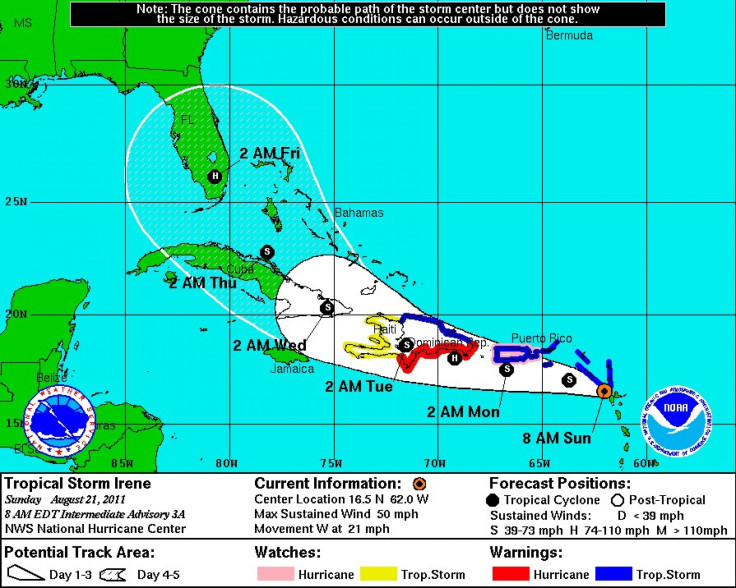
Residents in Florida should be keeping a close eye on Tropical Storm Irene, as it could strengthen into a hurricane and possible hit the state on Thursday, according to the National Hurricane Center, which also said the storm's path is uncertain.
The southeastern United States in general and Florida in particular should be paying attention to this storm, Meteorologist Dennis Feltgen, spokesman for the National Hurricane Center, told USA Today. Make sure you have your hurricane plan in place.
Irene, which is the ninth storm for the 2011 Atlantic hurricane season, formed on Saturday east of the Caribbean's Leeward Islands. It was heading westward and forecasted to pass near or over Puerto Rico and Hispaniola, which is a share island between the Dominican Republic and Haiti.
As of 11 p.m. AST on Sunday, the tropical storm was located about 50 miles south-east of San Juan, Puerto Rico. It's packing maximum sustained winds of 70 miles per hour and moving at 15 miles per hour.
The hurrcane center said Irene has continued to become better organized over the past few hours, as its circulation has become much better defined.
The intencity of Irene will largely be determined by how much the cyclone interacts with land in the next 24 to 36 hours, according to a forecast on the center's Web site. Irene could become a hurricane before moving over Puerto Rico.
Such storms usually weaken when they pass over land, Feltgen told USA Today. Once Irene passes over Cuba and enters the Florida straits, it could strengthen again over the warm water, he added.
© Copyright IBTimes 2025. All rights reserved.
- MOST POPULAR IN Society


